Riudecols geodata
Riudecols (Catalonia) is a seat of a third-order administrative division; located in Spain in Europe/Madrid (GMT+2) time zone. With population of 1,093 people, there are 2829 cities with bigger population in this country. Compared to other cities in Spain, 52.5% of cities are located further ↓South; 90.4% of cities are located further ←West and 73.8% of cities have higher elevation than Riudecols. Note1


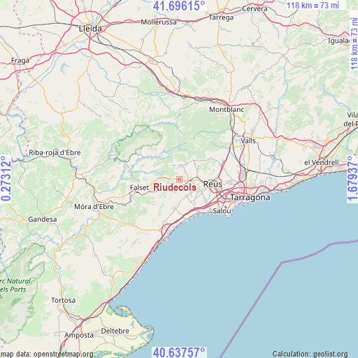
Riudecols GPS coordinates[2]
41° 10' 8.4" North, 0° 58' 34.5" East
| Map corner | latitude | longitude |
|---|---|---|
| Upper-left | 41.69615°, | 0.27312° |
| Center: | 41.169°, | 0.97625° |
| Lower-right: | 40.63757°, | 1.67937° |
| Map W x H: | 117.7×117.7 km | = 73.1×73.1mi |
| max Lat: | 43.74134° ⇑47.5% North |
| Riudecols: | 41.169° |
| min Lat: | ⇓52.5% South 27.64134° |
| min Long | Riudecols | max Long |
| -18.00367° | 0.97625° | 4.2899° |
| W 90.4%⇐ | ⇒9.6% E |
Elevation
Elevation of Riudecols is 318 m = 1043 ft, and this is 280 m = 919 ft below average elevation for this country.
| Max E: |
1682 m = 5518 ft | 73.8% |
| Avg. | 598 m = 1962 ft | |
| Riudecols | 318 m = 1043 ft | |
Min E: |
0 m = 0 ft | 26.2% |
See also: Spain elevation on elevation.city.
Geographical zone
Riudecols is located in North temperate zone (between Tropic of Cancer and the Arctic Circle). Distance of this Northern Tropic circle is 1971.6 km =1225.1 mi to South.| Distance of | km | miles | from Riudecols |
|---|---|---|---|
| North Pole | 5429.5 | 3373.7 | to North |
| Arctic Circle | 2823.6 | 1754.5 | to North |
| Tropic Cancer | 1971.6 | 1225.1 | to South |
| Equator | 4577.6 | 2844.4 | to South |


Nearby cities:
15 places around Riudecols: (largest is in red/bold)
• Alforja
4.7 km =2.9 mi,  359°
359°
• Almoster
11.8 km =7.3 mi,  74°
74°
• Botarell
3.8 km =2.4 mi,  163°
163°
• Colldejou
10.7 km =6.6 mi,  224°
224°
• Cornudella de Montsant
12.3 km =7.6 mi,  331°
331°
• Duesaigües
4.2 km =2.6 mi,  239°
239°
• Maspujols
6 km =3.7 mi,  75°
75°
• Mont-roig del Camp
9.3 km =5.8 mi,  188°
188°
• Porrera
10.3 km =6.4 mi,  282°
282°
• Reus
11 km =6.8 mi,  97°
97°
• Riudecanyes
4 km =2.5 mi, 191°
• Riudoms
7.3 km =4.5 mi,  122°
122°
• Vilanova d'Escornalbou
6.8 km =4.2 mi,  211°
211°
• Vilaplana
8.1 km =5 mi,  36°
36°
• les Borges del Camp
3.4 km =2.1 mi,  94°
94°
Sources, notices
• [Note1] Compared only with cities in Spain existing in our database
• [Src1] Map data: © OpenStreetMap contributors (CC-BY-SA)
• [Src2] Other city data from geonames.org with taken over terms of usage.
• [Src3] Geographical zone / Annual Mean Temperature by Robert A. Rohde @ Wikipedia
