Vilaplana geodata
Vilaplana (Catalonia) is a seat of a third-order administrative division; located in Spain in Europe/Madrid (GMT+2) time zone. With population of 564 people, there are 3701 cities with bigger population in this country. Compared to other cities in Spain, 53.9% of cities are located further ↓South; 90.6% of cities are located further ←West and 70.7% of cities have higher elevation than Vilaplana. Note1


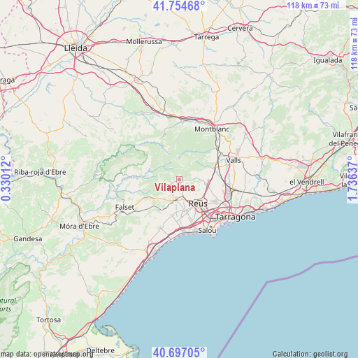
Vilaplana GPS coordinates[2]
41° 13' 40.8" North, 1° 1' 59.7" East
| Map corner | latitude | longitude |
|---|---|---|
| Upper-left | 41.75468°, | 0.33012° |
| Center: | 41.228°, | 1.03325° |
| Lower-right: | 40.69705°, | 1.73637° |
| Map W x H: | 117.6×117.6 km | = 73.1×73.1mi |
| max Lat: | 43.74134° ⇑46.1% North |
| Vilaplana: | 41.228° |
| min Lat: | ⇓53.9% South 27.64134° |
| min Long | Vilaplana | max Long |
| -18.00367° | 1.03325° | 4.2899° |
| W 90.6%⇐ | ⇒9.4% E |
Elevation
Elevation of Vilaplana is 371 m = 1217 ft, and this is 227 m = 745 ft below average elevation for this country.
| Max E: |
1682 m = 5518 ft | 70.7% |
| Avg. | 598 m = 1962 ft | |
| Vilaplana | 371 m = 1217 ft | |
Min E: |
0 m = 0 ft | 29.3% |
See also: Spain elevation on elevation.city.
Geographical zone
Vilaplana is located in North temperate zone (between Tropic of Cancer and the Arctic Circle). Distance of this Northern Tropic circle is 1978.2 km =1229.2 mi to South.| Distance of | km | miles | from Vilaplana |
|---|---|---|---|
| North Pole | 5422.9 | 3369.6 | to North |
| Arctic Circle | 2817.1 | 1750.5 | to North |
| Tropic Cancer | 1978.2 | 1229.2 | to South |
| Equator | 4584.1 | 2848.4 | to South |


Nearby cities:
15 places around Vilaplana: (largest is in red/bold)
• Alforja
5.2 km =3.2 mi,  248°
248°
• Almoster
7.4 km =4.6 mi,  117°
117°
• Botarell
10.8 km =6.7 mi,  199°
199°
• Capafonts
8 km =5 mi,  0°
0°
• Cornudella de Montsant
11.5 km =7.1 mi,  291°
291°
• Duesaigües
12 km =7.5 mi,  223°
223°
• La Selva del Camp
9 km =5.6 mi,  99°
99°
• Maspujols
5.2 km =3.2 mi,  168°
168°
• Mont-ral
8.3 km =5.2 mi,  42°
42°
• Prades
9.8 km =6.1 mi,  337°
337°
• Reus
10.1 km =6.3 mi,  142°
142°
• Riudecanyes
11.9 km =7.4 mi,  207°
207°
• Riudecols
8.1 km =5 mi, 216°
• Riudoms
10.6 km =6.6 mi, 172°
• les Borges del Camp
7 km =4.3 mi,  191°
191°
Sources, notices
• [Note1] Compared only with cities in Spain existing in our database
• [Src1] Map data: © OpenStreetMap contributors (CC-BY-SA)
• [Src2] Other city data from geonames.org with taken over terms of usage.
• [Src3] Geographical zone / Annual Mean Temperature by Robert A. Rohde @ Wikipedia
