Puebla de San Miguel geodata
Puebla de San Miguel (Valencia) is a seat of a third-order administrative division; located in Spain in Europe/Madrid (GMT+2) time zone. With population of 68 people, there are 6263 cities with bigger population in this country. Compared to other cities in Spain, 69.6% of cities are located further ↑North; 76.1% of cities are located further ←West and 97.1% of cities have lower elevation than Puebla de San Miguel. Note1
Administrative division(s):
- Level 1: Valencia
- Level 2: Província de València
- Level 3: Puebla de San Miguel


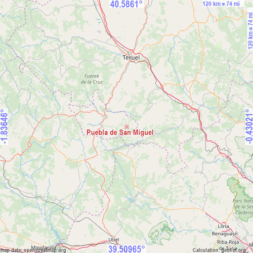
Puebla de San Miguel GPS coordinates[2]
40° 3' 0" North, 1° 7' 59.988" West
| Map corner | latitude | longitude |
|---|---|---|
| Upper-left | 40.5861°, | -1.83646° |
| Center: | 40.05°, | -1.13333° |
| Lower-right: | 39.50965°, | -0.43021° |
| Map W x H: | 119.7×119.7 km | = 74.4×74.4mi |
| max Lat: | 43.74134° ⇑69.6% North |
| Puebla de San Miguel: | 40.05° |
| min Lat: | ⇓30.4% South 27.64134° |
| min Long | Puebla de San M | max Long |
| -18.00367° | -1.13333° | 4.2899° |
| W 76.1%⇐ | ⇒23.9% E |
Elevation
Elevation of Puebla de San Miguel is 1211 m = 3973 ft, and this is 613 m = 2011 ft above average elevation for this country.
| Max E: |
1682 m = 5518 ft | 2.9% |
| Puebla de San Miguel | 1211 m 3973 ft | |
| Avg. | 598 m = 1962 ft | |
Min E: |
0 m = 0 ft | 97.1% |
See also: Spain elevation on elevation.city.
Geographical zone
Puebla de San Miguel is located in North temperate zone (between Tropic of Cancer and the Arctic Circle). Distance of this Northern Tropic circle is 1847.2 km =1147.8 mi to South.| Distance of | km | miles | from Puebla de San Miguel |
|---|---|---|---|
| North Pole | 5553.9 | 3451 | to North |
| Arctic Circle | 2948 | 1831.8 | to North |
| Tropic Cancer | 1847.2 | 1147.8 | to South |
| Equator | 4453.1 | 2767 | to South |


Nearby cities:
15 places around Puebla de San Miguel: (largest is in red/bold)
• Ademuz
13.1 km =8.1 mi,  275°
275°
• Arcos de las Salinas
11.3 km =7 mi,  131°
131°
• Camarena de la Sierra
14 km =8.7 mi,  37°
37°
• Casas Altas
11.5 km =7.1 mi,  260°
260°
• Casas Bajas
11.9 km =7.4 mi,  251°
251°
• Cascante del Río
16.4 km =10.2 mi,  5°
5°
• Castielfabib
17.1 km =10.6 mi,  301°
301°
• Cubla
18.4 km =11.4 mi, 14°
• Libros
15.2 km =9.4 mi,  325°
325°
• Riodeva
7.5 km =4.7 mi,  349°
349°
• Santa Cruz de Moya
15.9 km =9.9 mi,  225°
225°
• Torrijas
16 km =9.9 mi,  103°
103°
• Tramacastiel
17.9 km =11.1 mi, 329°
• Valacloche
16.1 km =10 mi, 12°
• Vallanca
17.1 km =10.6 mi, 276°
Sources, notices
• [Note1] Compared only with cities in Spain existing in our database
• [Src1] Map data: © OpenStreetMap contributors (CC-BY-SA)
• [Src2] Other city data from geonames.org with taken over terms of usage.
• [Src3] Geographical zone / Annual Mean Temperature by Robert A. Rohde @ Wikipedia
