Ribadesella geodata
Ribadesella (Asturias) is a seat of a third-order administrative division; located in Spain in Europe/Madrid (GMT+2) time zone. With population of 6,245 people, there are 1105 cities with bigger population in this country. Compared to other cities in Spain, 99.3% of cities are located further ↓South; 73.3% of cities are located further →East and 96% of cities have higher elevation than Ribadesella. Note1


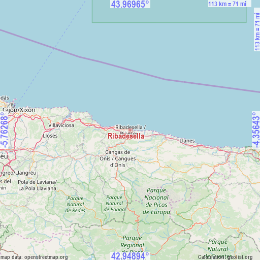
Ribadesella GPS coordinates[2]
43° 27' 41.22" North, 5° 3' 34.38" West
| Map corner | latitude | longitude |
|---|---|---|
| Upper-left | 43.96965°, | -5.76268° |
| Center: | 43.46145°, | -5.05955° |
| Lower-right: | 42.94894°, | -4.35643° |
| Map W x H: | 113.5×113.5 km | = 70.5×70.5mi |
| max Lat: | 43.74134° ⇑0.7% North |
| Ribadesella: | 43.46145° |
| min Lat: | ⇓99.3% South 27.64134° |
| min Long | Ribadesella | max Long |
| -18.00367° | -5.05955° | 4.2899° |
| W 26.7%⇐ | ⇒73.3% E |
Elevation
Elevation of Ribadesella is 20 m = 66 ft, and this is 578 m = 1896 ft below average elevation for this country.
| Max E: |
1682 m = 5518 ft | 96% |
| Avg. | 598 m = 1962 ft | |
| Ribadesella | 20 m = 66 ft | |
Min E: |
0 m = 0 ft | 4% |
See also: Spain elevation on elevation.city.
Geographical zone
Ribadesella is located in North temperate zone (between Tropic of Cancer and the Arctic Circle). Distance of this Northern Tropic circle is 2226.5 km =1383.5 mi to South.| Distance of | km | miles | from Ribadesella |
|---|---|---|---|
| North Pole | 5174.6 | 3215.3 | to North |
| Arctic Circle | 2568.7 | 1596.1 | to North |
| Tropic Cancer | 2226.5 | 1383.5 | to South |
| Equator | 4832.5 | 3002.8 | to South |


Nearby cities:
15 places around Ribadesella: (largest is in red/bold)
• Amieva
24.2 km =15 mi,  182°
182°
• Campo de Caso
38.6 km =24 mi,  216°
216°
• Cangas de Onís
13.5 km =8.4 mi,  204°
204°
• Caravia
10.7 km =6.6 mi,  269°
269°
• Carreña
23.5 km =14.6 mi,  132°
132°
• Colunga
17.2 km =10.7 mi,  278°
278°
• Llanes
25 km =15.5 mi,  100°
100°
• Nava
38.2 km =23.7 mi,  252°
252°
• Onís
15.6 km =9.7 mi,  151°
151°
• Oseja de Sajambre
36.2 km =22.5 mi, 177°
• Parres
14.4 km =8.9 mi,  210°
210°
• Piloña
27.7 km =17.2 mi,  243°
243°
• Posada de Valdeón
36.2 km =22.5 mi,  161°
161°
• Santa Eulalia
28.8 km =17.9 mi,  259°
259°
• Villaviciosa
30.4 km =18.9 mi, 274°
Sources, notices
• [Note1] Compared only with cities in Spain existing in our database
• [Src1] Map data: © OpenStreetMap contributors (CC-BY-SA)
• [Src2] Other city data from geonames.org with taken over terms of usage.
• [Src3] Geographical zone / Annual Mean Temperature by Robert A. Rohde @ Wikipedia
