Llanes geodata
Llanes (Asturias) is a seat of a third-order administrative division; located in Spain in Europe/Madrid (GMT+2) time zone. With population of 14,013 people, there are 659 cities with bigger population in this country. Compared to other cities in Spain, 99% of cities are located further ↓South; 69.2% of cities are located further →East and 97.6% of cities have higher elevation than Llanes. Note1


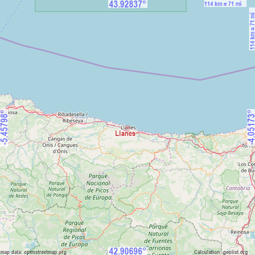
Llanes GPS coordinates[2]
43° 25' 11.352" North, 4° 45' 17.46" West
| Map corner | latitude | longitude |
|---|---|---|
| Upper-left | 43.92837°, | -5.45798° |
| Center: | 43.41982°, | -4.75485° |
| Lower-right: | 42.90696°, | -4.05173° |
| Map W x H: | 113.6×113.6 km | = 70.6×70.6mi |
| max Lat: | 43.74134° ⇑1% North |
| Llanes: | 43.41982° |
| min Lat: | ⇓99% South 27.64134° |
| min Long | Llanes | max Long |
| -18.00367° | -4.75485° | 4.2899° |
| W 30.8%⇐ | ⇒69.2% E |
Elevation
Elevation of Llanes is 13 m = 43 ft, and this is 585 m = 1919 ft below average elevation for this country.
| Max E: |
1682 m = 5518 ft | 97.6% |
| Avg. | 598 m = 1962 ft | |
| Llanes | 13 m = 43 ft | |
Min E: |
0 m = 0 ft | 2.4% |
See also: Spain elevation on elevation.city.
Geographical zone
Llanes is located in North temperate zone (between Tropic of Cancer and the Arctic Circle). Distance of this Northern Tropic circle is 2221.9 km =1380.6 mi to South.| Distance of | km | miles | from Llanes |
|---|---|---|---|
| North Pole | 5179.2 | 3218.2 | to North |
| Arctic Circle | 2573.3 | 1599 | to North |
| Tropic Cancer | 2221.9 | 1380.6 | to South |
| Equator | 4827.8 | 2999.9 | to South |


Nearby cities:
15 places around Llanes: (largest is in red/bold)
• Amieva
32.4 km =20.1 mi,  232°
232°
• Cabezón de Liébana
34.9 km =21.7 mi,  155°
155°
• Camaleño
30.3 km =18.8 mi,  170°
170°
• Cangas de Onís
31.2 km =19.4 mi,  255°
255°
• Caravia
35.6 km =22.1 mi,  277°
277°
• Carreña
13.6 km =8.5 mi,  212°
212°
• Comillas
37.6 km =23.4 mi,  95°
95°
• Onís
19.3 km =12 mi,  242°
242°
• Oseja de Sajambre
38.9 km =24.2 mi,  216°
216°
• Parres
32.9 km =20.4 mi, 256°
• Posada de Valdeón
32.7 km =20.3 mi,  204°
204°
• Potes
31.4 km =19.5 mi, 159°
• Ribadesella
25 km =15.5 mi, 280°
• San Vicente de la Barquera
29 km =18 mi, 97°
• Tresviso
19.4 km =12.1 mi, 158°
Sources, notices
• [Note1] Compared only with cities in Spain existing in our database
• [Src1] Map data: © OpenStreetMap contributors (CC-BY-SA)
• [Src2] Other city data from geonames.org with taken over terms of usage.
• [Src3] Geographical zone / Annual Mean Temperature by Robert A. Rohde @ Wikipedia
