Ramiro geodata
Ramiro (Castille and León) is a seat of a third-order administrative division; located in Spain in Europe/Madrid (GMT+2) time zone. With population of 71 people, there are 6234 cities with bigger population in this country. Compared to other cities in Spain, 53.9% of cities are located further ↓South; 69.6% of cities are located further →East and 62.5% of cities have lower elevation than Ramiro. Note1
Administrative division(s):
- Level 1: Castille and León
- Level 2: Provincia de Valladolid
- Level 3: Ramiro


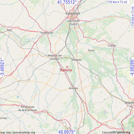
Ramiro GPS coordinates[2]
41° 13' 42.42" North, 4° 47' 9.888" West
| Map corner | latitude | longitude |
|---|---|---|
| Upper-left | 41.75512°, | -5.48921° |
| Center: | 41.22845°, | -4.78608° |
| Lower-right: | 40.6975°, | -4.08296° |
| Map W x H: | 117.6×117.6 km | = 73.1×73.1mi |
| max Lat: | 43.74134° ⇑46.1% North |
| Ramiro: | 41.22845° |
| min Lat: | ⇓53.9% South 27.64134° |
| min Long | Ramiro | max Long |
| -18.00367° | -4.78608° | 4.2899° |
| W 30.4%⇐ | ⇒69.6% E |
Elevation
Elevation of Ramiro is 761 m = 2497 ft, and this is 163 m = 535 ft above average elevation for this country.
| Max E: |
1682 m = 5518 ft | 37.5% |
| Ramiro | 761 m 2497 ft | |
| Avg. | 598 m = 1962 ft | |
Min E: |
0 m = 0 ft | 62.5% |
See also: Spain elevation on elevation.city.
Geographical zone
Ramiro is located in North temperate zone (between Tropic of Cancer and the Arctic Circle). Distance of this Northern Tropic circle is 1978.3 km =1229.3 mi to South.| Distance of | km | miles | from Ramiro |
|---|---|---|---|
| North Pole | 5422.9 | 3369.6 | to North |
| Arctic Circle | 2817 | 1750.4 | to North |
| Tropic Cancer | 1978.3 | 1229.3 | to South |
| Equator | 4584.2 | 2848.5 | to South |


Nearby cities:
15 places around Ramiro: (largest is in red/bold)
• Aguasal
12.3 km =7.6 mi,  65°
65°
• Almenara de Adaja
9.2 km =5.7 mi,  100°
100°
• Ataquines
5.3 km =3.3 mi,  195°
195°
• Bocigas
8.8 km =5.5 mi,  88°
88°
• Fuente de Santa Cruz
12.8 km =8 mi, 99°
• Fuente el Sol
13.7 km =8.5 mi,  244°
244°
• Montejo de Arévalo
14.2 km =8.8 mi,  133°
133°
• Moraleja de las Panaderas
6.3 km =3.9 mi,  328°
328°
• Olmedo
10.4 km =6.5 mi,  51°
51°
• Palacios de Goda
12.3 km =7.6 mi,  179°
179°
• Pozal de Gallinas
10.9 km =6.8 mi,  335°
335°
• Puras
12.4 km =7.7 mi,  113°
113°
• Rubí de Bracamonte
11.7 km =7.3 mi,  262°
262°
• San Pablo de la Moraleja
7.5 km =4.7 mi,  174°
174°
• San Vicente del Palacio
5.6 km =3.5 mi, 259°
Sources, notices
• [Note1] Compared only with cities in Spain existing in our database
• [Src1] Map data: © OpenStreetMap contributors (CC-BY-SA)
• [Src2] Other city data from geonames.org with taken over terms of usage.
• [Src3] Geographical zone / Annual Mean Temperature by Robert A. Rohde @ Wikipedia
