Olmedo geodata
Olmedo (Castille and León) is a seat of a third-order administrative division; located in Spain in Europe/Madrid (GMT+2) time zone. With population of 3,570 people, there are 1572 cities with bigger population in this country. Compared to other cities in Spain, 55.1% of cities are located further ↓South; 68.5% of cities are located further →East and 63.5% of cities have lower elevation than Olmedo. Note1
Administrative division(s):
- Level 1: Castille and León
- Level 2: Provincia de Valladolid
- Level 3: Olmedo


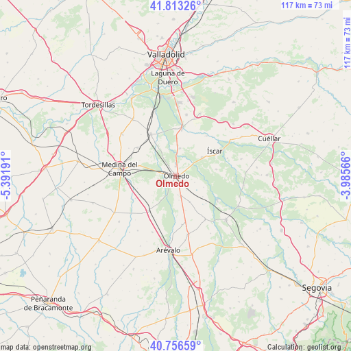
Olmedo GPS coordinates[2]
41° 17' 13.416" North, 4° 41' 19.608" West
| Map corner | latitude | longitude |
|---|---|---|
| Upper-left | 41.81326°, | -5.39191° |
| Center: | 41.28706°, | -4.68878° |
| Lower-right: | 40.75659°, | -3.98566° |
| Map W x H: | 117.5×117.5 km | = 73×73mi |
| max Lat: | 43.74134° ⇑44.9% North |
| Olmedo: | 41.28706° |
| min Lat: | ⇓55.1% South 27.64134° |
| min Long | Olmedo | max Long |
| -18.00367° | -4.68878° | 4.2899° |
| W 31.5%⇐ | ⇒68.5% E |
Elevation
Elevation of Olmedo is 767 m = 2516 ft, and this is 169 m = 554 ft above average elevation for this country.
| Max E: |
1682 m = 5518 ft | 36.5% |
| Olmedo | 767 m 2516 ft | |
| Avg. | 598 m = 1962 ft | |
Min E: |
0 m = 0 ft | 63.5% |
See also: Spain elevation on elevation.city.
Geographical zone
Olmedo is located in North temperate zone (between Tropic of Cancer and the Arctic Circle). Distance of this Northern Tropic circle is 1984.8 km =1233.3 mi to South.| Distance of | km | miles | from Olmedo |
|---|---|---|---|
| North Pole | 5416.4 | 3365.6 | to North |
| Arctic Circle | 2810.5 | 1746.4 | to North |
| Tropic Cancer | 1984.8 | 1233.3 | to South |
| Equator | 4590.7 | 2852.5 | to South |


Nearby cities:
15 places around Olmedo: (largest is in red/bold)
• Aguasal
3.3 km =2.1 mi,  114°
114°
• Alcazarén
9.4 km =5.8 mi,  8°
8°
• Almenara de Adaja
8.2 km =5.1 mi,  173°
173°
• Ataquines
15.1 km =9.4 mi,  219°
219°
• Bocigas
6.3 km =3.9 mi, 174°
• Fuente de Santa Cruz
9.7 km =6 mi,  152°
152°
• Iscar
15.4 km =9.6 mi,  57°
57°
• Llano de Olmedo
6.6 km =4.1 mi, 109°
• Moraleja de las Panaderas
11.5 km =7.1 mi,  264°
264°
• Pedrajas de San Esteban
10.8 km =6.7 mi, 55°
• Pozal de Gallinas
13 km =8.1 mi,  285°
285°
• Puras
12 km =7.5 mi,  164°
164°
• Ramiro
10.4 km =6.5 mi,  231°
231°
• Villaverde de Iscar
13.6 km =8.5 mi,  80°
80°
• Villeguillo
9.9 km =6.2 mi, 112°
Sources, notices
• [Note1] Compared only with cities in Spain existing in our database
• [Src1] Map data: © OpenStreetMap contributors (CC-BY-SA)
• [Src2] Other city data from geonames.org with taken over terms of usage.
• [Src3] Geographical zone / Annual Mean Temperature by Robert A. Rohde @ Wikipedia
