Quemada geodata
Quemada (Castille and León) is a seat of a third-order administrative division; located in Spain in Europe/Madrid (GMT+2) time zone. With population of 257 people, there are 4702 cities with bigger population in this country. Compared to other cities in Spain, 66.2% of cities are located further ↓South; 53.3% of cities are located further →East and 74.9% of cities have lower elevation than Quemada. Note1
Administrative division(s):
- Level 1: Castille and León
- Level 2: Provincia de Burgos
- Level 3: Quemada


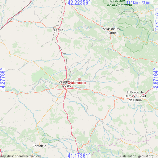
Quemada GPS coordinates[2]
41° 42' 2.628" North, 3° 34' 29.136" West
| Map corner | latitude | longitude |
|---|---|---|
| Upper-left | 42.22356°, | -4.27789° |
| Center: | 41.70073°, | -3.57476° |
| Lower-right: | 41.17361°, | -2.87164° |
| Map W x H: | 116.7×116.7 km | = 72.5×72.5mi |
| max Lat: | 43.74134° ⇑33.8% North |
| Quemada: | 41.70073° |
| min Lat: | ⇓66.2% South 27.64134° |
| min Long | Quemada | max Long |
| -18.00367° | -3.57476° | 4.2899° |
| W 46.7%⇐ | ⇒53.3% E |
Elevation
Elevation of Quemada is 850 m = 2789 ft, and this is 252 m = 827 ft above average elevation for this country.
| Max E: |
1682 m = 5518 ft | 25.1% |
| Quemada | 850 m 2789 ft | |
| Avg. | 598 m = 1962 ft | |
Min E: |
0 m = 0 ft | 74.9% |
See also: Spain elevation on elevation.city.
Geographical zone
Quemada is located in North temperate zone (between Tropic of Cancer and the Arctic Circle). Distance of this Northern Tropic circle is 2030.8 km =1261.9 mi to South.| Distance of | km | miles | from Quemada |
|---|---|---|---|
| North Pole | 5370.4 | 3337 | to North |
| Arctic Circle | 2764.5 | 1717.8 | to North |
| Tropic Cancer | 2030.8 | 1261.9 | to South |
| Equator | 4636.7 | 2881.1 | to South |


Nearby cities:
15 places around Quemada: (largest is in red/bold)
• Aranda de Duero
10.1 km =6.3 mi,  250°
250°
• Arandilla
12.8 km =8 mi,  71°
71°
• Baños de Valdearados
7.9 km =4.9 mi,  11°
11°
• Fresnillo de las Dueñas
8.4 km =5.2 mi,  224°
224°
• Fuentespina
12 km =7.5 mi,  229°
229°
• Gumiel de Izán
12.3 km =7.6 mi,  310°
310°
• Hontoria de Valdearados
6.7 km =4.2 mi,  42°
42°
• Peñaranda de Duero
8.1 km =5 mi,  99°
99°
• San Juan del Monte
4.7 km =2.9 mi,  114°
114°
• Santa Cruz de la Salceda
11.8 km =7.3 mi,  187°
187°
• Tubilla del Lago
11.2 km =7 mi,  355°
355°
• Vadocondes
6.8 km =4.2 mi,  179°
179°
• Villalbilla de Gumiel
12.5 km =7.8 mi,  340°
340°
• Villanueva de Gumiel
6 km =3.7 mi, 313°
• Zazuar
1.8 km =1.1 mi, 109°
Sources, notices
• [Note1] Compared only with cities in Spain existing in our database
• [Src1] Map data: © OpenStreetMap contributors (CC-BY-SA)
• [Src2] Other city data from geonames.org with taken over terms of usage.
• [Src3] Geographical zone / Annual Mean Temperature by Robert A. Rohde @ Wikipedia
