Aranda de Duero geodata
Aranda de Duero (Castille and León) is a seat of a third-order administrative division; located in Spain in Europe/Madrid (GMT+2) time zone. With population of 32,928 people, there are 273 cities with bigger population in this country. Compared to other cities in Spain, 65.2% of cities are located further ↓South; 55.2% of cities are located further →East and 68.1% of cities have lower elevation than Aranda de Duero. Note1
Administrative division(s):
- Level 1: Castille and León
- Level 2: Provincia de Burgos
- Level 3: Aranda de Duero


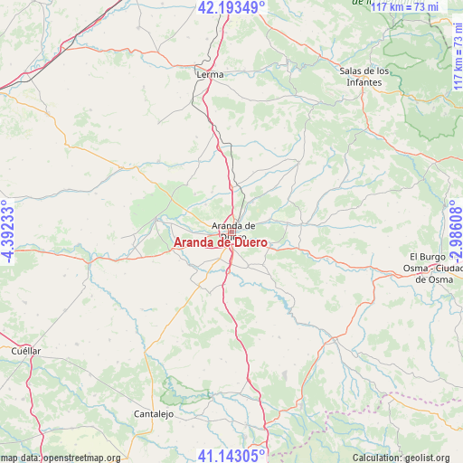
Aranda de Duero GPS coordinates[2]
41° 40' 13.476" North, 3° 41' 21.12" West
| Map corner | latitude | longitude |
|---|---|---|
| Upper-left | 42.19349°, | -4.39233° |
| Center: | 41.67041°, | -3.6892° |
| Lower-right: | 41.14305°, | -2.98608° |
| Map W x H: | 116.8×116.8 km | = 72.6×72.6mi |
| max Lat: | 43.74134° ⇑34.8% North |
| Aranda de Duero: | 41.67041° |
| min Lat: | ⇓65.2% South 27.64134° |
| min Long | Aranda de Duero | max Long |
| -18.00367° | -3.6892° | 4.2899° |
| W 44.8%⇐ | ⇒55.2% E |
Elevation
Elevation of Aranda de Duero is 800 m = 2625 ft, and this is 202 m = 663 ft above average elevation for this country.
| Max E: |
1682 m = 5518 ft | 31.9% |
| Aranda de Duero | 800 m 2625 ft | |
| Avg. | 598 m = 1962 ft | |
Min E: |
0 m = 0 ft | 68.1% |
See also: Spain elevation on elevation.city.
Geographical zone
Aranda de Duero is located in North temperate zone (between Tropic of Cancer and the Arctic Circle). Distance of this Northern Tropic circle is 2027.4 km =1259.8 mi to South.| Distance of | km | miles | from Aranda de Duero |
|---|---|---|---|
| North Pole | 5373.7 | 3339.1 | to North |
| Arctic Circle | 2767.9 | 1719.9 | to North |
| Tropic Cancer | 2027.4 | 1259.8 | to South |
| Equator | 4633.3 | 2879 | to South |


Nearby cities:
15 places around Aranda de Duero: (largest is in red/bold)
• Campillo de Aranda
7.5 km =4.7 mi,  206°
206°
• Castrillo de la Vega
7.9 km =4.9 mi,  254°
254°
• Fresnillo de las Dueñas
4.5 km =2.8 mi,  125°
125°
• Fuentelcésped
9.6 km =6 mi,  155°
155°
• Fuentespina
4.4 km =2.7 mi,  175°
175°
• Gumiel de Izán
11.4 km =7.1 mi,  0°
0°
• Milagros
10.6 km =6.6 mi, 184°
• Quemada
10.1 km =6.3 mi,  70°
70°
• Quintana del Pidio
11.1 km =6.9 mi,  332°
332°
• Santa Cruz de la Salceda
11.5 km =7.1 mi,  136°
136°
• Torregalindo
11 km =6.8 mi, 208°
• Vadocondes
10.2 km =6.3 mi,  109°
109°
• Villalba de Duero
4.8 km =3 mi,  286°
286°
• Villanueva de Gumiel
9.1 km =5.7 mi,  34°
34°
• Zazuar
11.5 km =7.1 mi,  76°
76°
Sources, notices
• [Note1] Compared only with cities in Spain existing in our database
• [Src1] Map data: © OpenStreetMap contributors (CC-BY-SA)
• [Src2] Other city data from geonames.org with taken over terms of usage.
• [Src3] Geographical zone / Annual Mean Temperature by Robert A. Rohde @ Wikipedia
