Fuentespina geodata
Fuentespina (Castille and León) is a seat of a third-order administrative division; located in Spain in Europe/Madrid (GMT+2) time zone. With population of 667 people, there are 3472 cities with bigger population in this country. Compared to other cities in Spain, 64.2% of cities are located further ↓South; 55.1% of cities are located further →East and 71.6% of cities have lower elevation than Fuentespina. Note1
Administrative division(s):
- Level 1: Castille and León
- Level 2: Provincia de Burgos
- Level 3: Fuentespina


Fuentespina GPS coordinates[2]
41° 37' 50.844" North, 3° 41' 5.1" West
| Map corner | latitude | longitude |
|---|---|---|
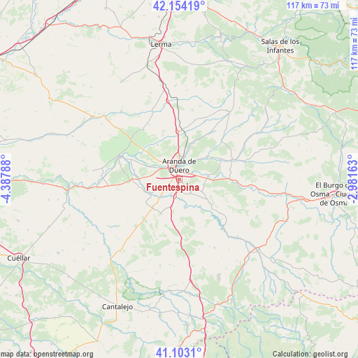
| Upper-left | 42.15419°, | -4.38788° |
| Center: | 41.63079°, | -3.68475° |
| Lower-right: | 41.1031°, | -2.98163° |
| Map W x H: | 116.9×116.9 km | = 72.6×72.6mi |
| max Lat: | 43.74134° ⇑35.8% North |
| Fuentespina: | 41.63079° |
| min Lat: | ⇓64.2% South 27.64134° |
| min Long | Fuentespina | max Long |
| -18.00367° | -3.68475° | 4.2899° |
| W 44.9%⇐ | ⇒55.1% E |
Elevation
Elevation of Fuentespina is 825 m = 2707 ft, and this is 227 m = 745 ft above average elevation for this country.
| Max E: |
1682 m = 5518 ft | 28.4% |
| Fuentespina | 825 m 2707 ft | |
| Avg. | 598 m = 1962 ft | |
Min E: |
0 m = 0 ft | 71.6% |
See also: Spain elevation on elevation.city.
Geographical zone
Fuentespina is located in North temperate zone (between Tropic of Cancer and the Arctic Circle). Distance of this Northern Tropic circle is 2023 km =1257 mi to South.| Distance of | km | miles | from Fuentespina |
|---|---|---|---|
| North Pole | 5378.2 | 3341.9 | to North |
| Arctic Circle | 2772.3 | 1722.6 | to North |
| Tropic Cancer | 2023 | 1257 | to South |
| Equator | 4628.9 | 2876.3 | to South |


Nearby cities:
15 places around Fuentespina: (largest is in red/bold)
• Aranda de Duero
4.4 km =2.7 mi,  355°
355°
• Campillo de Aranda
4.4 km =2.7 mi,  238°
238°
• Castrillo de la Vega
8.3 km =5.2 mi,  286°
286°
• Fresnillo de las Dueñas
3.7 km =2.3 mi,  61°
61°
• Fuentelcésped
5.7 km =3.5 mi,  139°
139°
• Haza
11.1 km =6.9 mi,  261°
261°
• Hontangas
10.7 km =6.6 mi, 239°
• Milagros
6.3 km =3.9 mi,  190°
190°
• Montejo de la Vega de la Serrezuela
9.3 km =5.8 mi,  164°
164°
• Pardilla
9 km =5.6 mi, 193°
• Quemada
12 km =7.5 mi,  49°
49°
• Santa Cruz de la Salceda
8.5 km =5.3 mi,  116°
116°
• Torregalindo
7.7 km =4.8 mi,  226°
226°
• Vadocondes
9.3 km =5.8 mi,  84°
84°
• Villalba de Duero
7.6 km =4.7 mi,  319°
319°
Sources, notices
• [Note1] Compared only with cities in Spain existing in our database
• [Src1] Map data: © OpenStreetMap contributors (CC-BY-SA)
• [Src2] Other city data from geonames.org with taken over terms of usage.
• [Src3] Geographical zone / Annual Mean Temperature by Robert A. Rohde @ Wikipedia
