Vadocondes geodata
Vadocondes (Castille and León) is a seat of a third-order administrative division; located in Spain in Europe/Madrid (GMT+2) time zone. With population of 412 people, there are 4106 cities with bigger population in this country. Compared to other cities in Spain, 64.5% of cities are located further ↓South; 53.2% of cities are located further →East and 69.5% of cities have lower elevation than Vadocondes. Note1
Administrative division(s):
- Level 1: Castille and León
- Level 2: Provincia de Burgos
- Level 3: Vadocondes


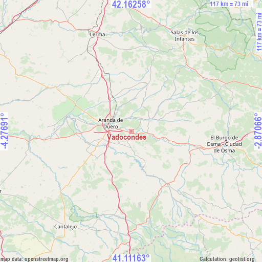
Vadocondes GPS coordinates[2]
41° 38' 21.3" North, 3° 34' 25.608" West
| Map corner | latitude | longitude |
|---|---|---|
| Upper-left | 42.16258°, | -4.27691° |
| Center: | 41.63925°, | -3.57378° |
| Lower-right: | 41.11163°, | -2.87066° |
| Map W x H: | 116.9×116.9 km | = 72.6×72.6mi |
| max Lat: | 43.74134° ⇑35.5% North |
| Vadocondes: | 41.63925° |
| min Lat: | ⇓64.5% South 27.64134° |
| min Long | Vadocondes | max Long |
| -18.00367° | -3.57378° | 4.2899° |
| W 46.8%⇐ | ⇒53.2% E |
Elevation
Elevation of Vadocondes is 810 m = 2657 ft, and this is 212 m = 696 ft above average elevation for this country.
| Max E: |
1682 m = 5518 ft | 30.5% |
| Vadocondes | 810 m 2657 ft | |
| Avg. | 598 m = 1962 ft | |
Min E: |
0 m = 0 ft | 69.5% |
See also: Spain elevation on elevation.city.
Geographical zone
Vadocondes is located in North temperate zone (between Tropic of Cancer and the Arctic Circle). Distance of this Northern Tropic circle is 2023.9 km =1257.6 mi to South.| Distance of | km | miles | from Vadocondes |
|---|---|---|---|
| North Pole | 5377.2 | 3341.2 | to North |
| Arctic Circle | 2771.3 | 1722 | to North |
| Tropic Cancer | 2023.9 | 1257.6 | to South |
| Equator | 4629.9 | 2876.9 | to South |


Nearby cities:
15 places around Vadocondes: (largest is in red/bold)
• Aranda de Duero
10.2 km =6.3 mi,  289°
289°
• Campillo de Aranda
13.4 km =8.3 mi,  256°
256°
• Castillejo de Robledo
11 km =6.8 mi,  144°
144°
• Fresnillo de las Dueñas
6 km =3.7 mi,  278°
278°
• Fuentelcésped
7.7 km =4.8 mi,  226°
226°
• Fuentespina
9.3 km =5.8 mi, 264°
• Hontoria de Valdearados
12.6 km =7.8 mi,  20°
20°
• Milagros
12.6 km =7.8 mi,  235°
235°
• Montejo de la Vega de la Serrezuela
11.9 km =7.4 mi,  214°
214°
• Peñaranda de Duero
9.6 km =6 mi,  55°
55°
• Quemada
6.8 km =4.2 mi,  359°
359°
• San Juan del Monte
6.4 km =4 mi,  40°
40°
• Santa Cruz de la Salceda
5.1 km =3.2 mi,  198°
198°
• Villanueva de Gumiel
11.8 km =7.3 mi,  338°
338°
• Zazuar
6.4 km =4 mi,  14°
14°
Sources, notices
• [Note1] Compared only with cities in Spain existing in our database
• [Src1] Map data: © OpenStreetMap contributors (CC-BY-SA)
• [Src2] Other city data from geonames.org with taken over terms of usage.
• [Src3] Geographical zone / Annual Mean Temperature by Robert A. Rohde @ Wikipedia
