Mont-ral geodata
Mont-ral (Catalonia) is a seat of a third-order administrative division; located in Spain in Europe/Madrid (GMT+2) time zone. In our database, there are 6762 cities with bigger population. Compared to other cities in Spain, 55% of cities are located further ↓South; 90.8% of cities are located further ←West and 66.3% of cities have lower elevation than Mont-ral. Note1


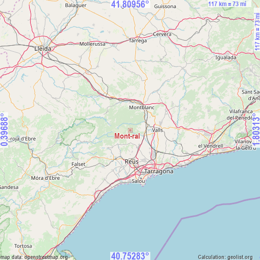
Mont-ral GPS coordinates[2]
41° 16' 59.988" North, 1° 6' 0" East
| Map corner | latitude | longitude |
|---|---|---|
| Upper-left | 41.80956°, | 0.39688° |
| Center: | 41.28333°, | 1.1° |
| Lower-right: | 40.75283°, | 1.80313° |
| Map W x H: | 117.5×117.5 km | = 73×73mi |
| max Lat: | 43.74134° ⇑45% North |
| Mont-ral: | 41.28333° |
| min Lat: | ⇓55% South 27.64134° |
| min Long | Mont-ral | max Long |
| -18.00367° | 1.1° | 4.2899° |
| W 90.8%⇐ | ⇒9.2% E |
Elevation
Elevation of Mont-ral is 787 m = 2582 ft, and this is 189 m = 620 ft above average elevation for this country.
| Max E: |
1682 m = 5518 ft | 33.7% |
| Mont-ral | 787 m 2582 ft | |
| Avg. | 598 m = 1962 ft | |
Min E: |
0 m = 0 ft | 66.3% |
See also: Spain elevation on elevation.city.
Geographical zone
Mont-ral is located in North temperate zone (between Tropic of Cancer and the Arctic Circle). Distance of this Northern Tropic circle is 1984.4 km =1233 mi to South.| Distance of | km | miles | from Mont-ral |
|---|---|---|---|
| North Pole | 5416.8 | 3365.8 | to North |
| Arctic Circle | 2810.9 | 1746.6 | to North |
| Tropic Cancer | 1984.4 | 1233 | to South |
| Equator | 4590.3 | 2852.3 | to South |


Nearby cities:
15 places around Mont-ral: (largest is in red/bold)
• Alcover
6.3 km =3.9 mi,  111°
111°
• Alforja
13.2 km =8.2 mi,  232°
232°
• Almoster
9.6 km =6 mi,  174°
174°
• Capafonts
5.9 km =3.7 mi,  288°
288°
• La Riba
7.4 km =4.6 mi,  56°
56°
• La Selva del Camp
8.3 km =5.2 mi,  156°
156°
• Maspujols
12.1 km =7.5 mi,  202°
202°
• Montblanc
11.6 km =7.2 mi,  26°
26°
• Prades
9.8 km =6.1 mi, 287°
• Reus
14.2 km =8.8 mi,  177°
177°
• Vallmoll
13.2 km =8.2 mi, 109°
• Valls
12.5 km =7.8 mi,  88°
88°
• Vilanova de Prades
14 km =8.7 mi,  301°
301°
• Vilaplana
8.3 km =5.2 mi,  222°
222°
• Vimbodí
13.7 km =8.5 mi,  342°
342°
Sources, notices
• [Note1] Compared only with cities in Spain existing in our database
• [Src1] Map data: © OpenStreetMap contributors (CC-BY-SA)
• [Src2] Other city data from geonames.org with taken over terms of usage.
• [Src3] Geographical zone / Annual Mean Temperature by Robert A. Rohde @ Wikipedia
