Portillo de Toledo geodata
Portillo de Toledo (Castille-La Mancha) is a seat of a third-order administrative division; located in Spain in Europe/Madrid (GMT+2) time zone. With population of 2,171 people, there are 2067 cities with bigger population in this country. Compared to other cities in Spain, 69.3% of cities are located further ↑North; 62.9% of cities are located further →East and 55.2% of cities have higher elevation than Portillo de Toledo. Note1
Administrative division(s):
- Level 1: Castille-La Mancha
- Level 2: Province of Toledo
- Level 3: Portillo de Toledo


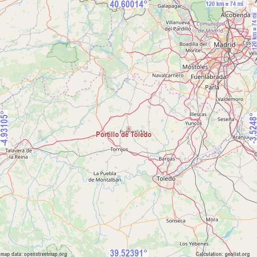
Portillo de Toledo GPS coordinates[2]
40° 3' 50.94" North, 4° 13' 40.548" West
| Map corner | latitude | longitude |
|---|---|---|
| Upper-left | 40.60014°, | -4.93105° |
| Center: | 40.06415°, | -4.22793° |
| Lower-right: | 39.52391°, | -3.5248° |
| Map W x H: | 119.7×119.7 km | = 74.4×74.4mi |
| max Lat: | 43.74134° ⇑69.3% North |
| Portillo de Toledo: | 40.06415° |
| min Lat: | ⇓30.7% South 27.64134° |
| min Long | Portillo de Tol | max Long |
| -18.00367° | -4.22793° | 4.2899° |
| W 37.1%⇐ | ⇒62.9% E |
Elevation
Elevation of Portillo de Toledo is 593 m = 1946 ft, and this is 5 m = 16 ft below average elevation for this country.
| Max E: |
1682 m = 5518 ft | 55.2% |
| Avg. | 598 m = 1962 ft | |
| Portillo de Toledo | 593 m = 1946 ft | |
Min E: |
0 m = 0 ft | 44.8% |
See also: Spain elevation on elevation.city.
Geographical zone
Portillo de Toledo is located in North temperate zone (between Tropic of Cancer and the Arctic Circle). Distance of this Northern Tropic circle is 1848.8 km =1148.8 mi to South.| Distance of | km | miles | from Portillo de Toledo |
|---|---|---|---|
| North Pole | 5552.3 | 3450 | to North |
| Arctic Circle | 2946.5 | 1830.9 | to North |
| Tropic Cancer | 1848.8 | 1148.8 | to South |
| Equator | 4454.7 | 2768 | to South |


Nearby cities:
15 places around Portillo de Toledo: (largest is in red/bold)
• Alcabón
13.8 km =8.6 mi,  240°
240°
• Arcicóllar
9.5 km =5.9 mi,  96°
96°
• Barcience
9 km =5.6 mi,  183°
183°
• Camarena
9.8 km =6.1 mi,  70°
70°
• Camarenilla
13.9 km =8.6 mi,  112°
112°
• Fuensalida
2.2 km =1.4 mi,  125°
125°
• Gerindote
12.6 km =7.8 mi,  210°
210°
• Huecas
6.4 km =4 mi,  154°
154°
• La Torre de Esteban Hambrán
11.7 km =7.3 mi,  5°
5°
• Maqueda
12.1 km =7.5 mi,  271°
271°
• Novés
4.4 km =2.7 mi,  245°
245°
• Quismondo
9.4 km =5.8 mi,  299°
299°
• Rielves
11.7 km =7.3 mi,  165°
165°
• Santa Cruz del Retamar
6.2 km =3.9 mi,  349°
349°
• Torrijos
10.3 km =6.4 mi, 207°
Sources, notices
• [Note1] Compared only with cities in Spain existing in our database
• [Src1] Map data: © OpenStreetMap contributors (CC-BY-SA)
• [Src2] Other city data from geonames.org with taken over terms of usage.
• [Src3] Geographical zone / Annual Mean Temperature by Robert A. Rohde @ Wikipedia
