Fuensalida geodata
Fuensalida (Castille-La Mancha) is a seat of a third-order administrative division; located in Spain in Europe/Madrid (GMT+2) time zone. With population of 10,967 people, there are 805 cities with bigger population in this country. Compared to other cities in Spain, 69.4% of cities are located further ↑North; 62.7% of cities are located further →East and 55.2% of cities have higher elevation than Fuensalida. Note1
Administrative division(s):
- Level 1: Castille-La Mancha
- Level 2: Province of Toledo
- Level 3: Fuensalida


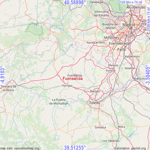
Fuensalida GPS coordinates[2]
40° 3' 10.368" North, 4° 12' 25.848" West
| Map corner | latitude | longitude |
|---|---|---|
| Upper-left | 40.58896°, | -4.9103° |
| Center: | 40.05288°, | -4.20718° |
| Lower-right: | 39.51255°, | -3.50405° |
| Map W x H: | 119.7×119.7 km | = 74.4×74.4mi |
| max Lat: | 43.74134° ⇑69.4% North |
| Fuensalida: | 40.05288° |
| min Lat: | ⇓30.6% South 27.64134° |
| min Long | Fuensalida | max Long |
| -18.00367° | -4.20718° | 4.2899° |
| W 37.3%⇐ | ⇒62.7% E |
Elevation
Elevation of Fuensalida is 592 m = 1942 ft, and this is 6 m = 20 ft below average elevation for this country.
| Max E: |
1682 m = 5518 ft | 55.2% |
| Avg. | 598 m = 1962 ft | |
| Fuensalida | 592 m = 1942 ft | |
Min E: |
0 m = 0 ft | 44.8% |
See also: Spain elevation on elevation.city.
Geographical zone
Fuensalida is located in North temperate zone (between Tropic of Cancer and the Arctic Circle). Distance of this Northern Tropic circle is 1847.5 km =1148 mi to South.| Distance of | km | miles | from Fuensalida |
|---|---|---|---|
| North Pole | 5553.6 | 3450.8 | to North |
| Arctic Circle | 2947.7 | 1831.6 | to North |
| Tropic Cancer | 1847.5 | 1148 | to South |
| Equator | 4453.5 | 2767.3 | to South |


Nearby cities:
15 places around Fuensalida: (largest is in red/bold)
• Arcicóllar
7.7 km =4.8 mi,  88°
88°
• Barcience
8 km =5 mi,  196°
196°
• Camarena
8.7 km =5.4 mi,  59°
59°
• Camarenilla
11.9 km =7.4 mi,  109°
109°
• Gerindote
12.6 km =7.8 mi,  220°
220°
• Huecas
4.6 km =2.9 mi,  167°
167°
• La Torre de Esteban Hambrán
13 km =8.1 mi,  356°
356°
• Las Ventas de Retamosa
13.8 km =8.6 mi,  34°
34°
• Novés
5.8 km =3.6 mi,  264°
264°
• Portillo de Toledo
2.2 km =1.4 mi,  305°
305°
• Quismondo
11.5 km =7.1 mi,  300°
300°
• Rielves
10.2 km =6.3 mi, 173°
• Santa Cruz del Retamar
7.9 km =4.9 mi,  338°
338°
• Torrijos
10.2 km =6.3 mi, 219°
• Villamiel de Toledo
12 km =7.5 mi,  144°
144°
Sources, notices
• [Note1] Compared only with cities in Spain existing in our database
• [Src1] Map data: © OpenStreetMap contributors (CC-BY-SA)
• [Src2] Other city data from geonames.org with taken over terms of usage.
• [Src3] Geographical zone / Annual Mean Temperature by Robert A. Rohde @ Wikipedia
