Camarenilla geodata
Camarenilla (Castille-La Mancha) is a seat of a third-order administrative division; located in Spain in Europe/Madrid (GMT+2) time zone. With population of 512 people, there are 3849 cities with bigger population in this country. Compared to other cities in Spain, 70% of cities are located further ↑North; 60.9% of cities are located further →East and 61% of cities have higher elevation than Camarenilla. Note1
Administrative division(s):
- Level 1: Castille-La Mancha
- Level 2: Province of Toledo
- Level 3: Camarenilla


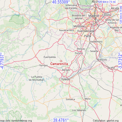
Camarenilla GPS coordinates[2]
40° 1' 0.192" North, 4° 4' 34.464" West
| Map corner | latitude | longitude |
|---|---|---|
| Upper-left | 40.55309°, | -4.77937° |
| Center: | 40.01672°, | -4.07624° |
| Lower-right: | 39.4761°, | -3.37312° |
| Map W x H: | 119.8×119.7 km | = 74.4×74.4mi |
| max Lat: | 43.74134° ⇑70% North |
| Camarenilla: | 40.01672° |
| min Lat: | ⇓30% South 27.64134° |
| min Long | Camarenilla | max Long |
| -18.00367° | -4.07624° | 4.2899° |
| W 39.1%⇐ | ⇒60.9% E |
Elevation
Elevation of Camarenilla is 512 m = 1680 ft, and this is 86 m = 282 ft below average elevation for this country.
| Max E: |
1682 m = 5518 ft | 61% |
| Avg. | 598 m = 1962 ft | |
| Camarenilla | 512 m = 1680 ft | |
Min E: |
0 m = 0 ft | 39% |
See also: Spain elevation on elevation.city.
Geographical zone
Camarenilla is located in North temperate zone (between Tropic of Cancer and the Arctic Circle). Distance of this Northern Tropic circle is 1843.5 km =1145.5 mi to South.| Distance of | km | miles | from Camarenilla |
|---|---|---|---|
| North Pole | 5557.6 | 3453.3 | to North |
| Arctic Circle | 2951.7 | 1834.1 | to North |
| Tropic Cancer | 1843.5 | 1145.5 | to South |
| Equator | 4449.4 | 2764.7 | to South |


Nearby cities:
15 places around Camarenilla: (largest is in red/bold)
• Arcicóllar
5.5 km =3.4 mi,  321°
321°
• Barcience
14 km =8.7 mi,  254°
254°
• Bargas
9.7 km =6 mi,  150°
150°
• Cabañas de la Sagra
11.2 km =7 mi,  96°
96°
• Camarena
9.2 km =5.7 mi,  336°
336°
• Chozas de Canales
9.7 km =6 mi,  16°
16°
• Fuensalida
11.9 km =7.4 mi,  289°
289°
• Huecas
10.2 km =6.3 mi,  267°
267°
• Lominchar
12.4 km =7.7 mi,  48°
48°
• Magán
13.8 km =8.6 mi,  116°
116°
• Olías del Rey
11.1 km =6.9 mi,  136°
136°
• Portillo de Toledo
13.9 km =8.6 mi, 292°
• Recas
8.3 km =5.2 mi,  61°
61°
• Rielves
11.7 km =7.3 mi,  238°
238°
• Villamiel de Toledo
7.2 km =4.5 mi,  216°
216°
Sources, notices
• [Note1] Compared only with cities in Spain existing in our database
• [Src1] Map data: © OpenStreetMap contributors (CC-BY-SA)
• [Src2] Other city data from geonames.org with taken over terms of usage.
• [Src3] Geographical zone / Annual Mean Temperature by Robert A. Rohde @ Wikipedia
