Novés geodata
Novés (Castille-La Mancha) is a seat of a third-order administrative division; located in Spain in Europe/Madrid (GMT+2) time zone. In our database, there are 6762 cities with bigger population. Compared to other cities in Spain, 69.6% of cities are located further ↑North; 63.5% of cities are located further →East and 57.7% of cities have higher elevation than Novés. Note1


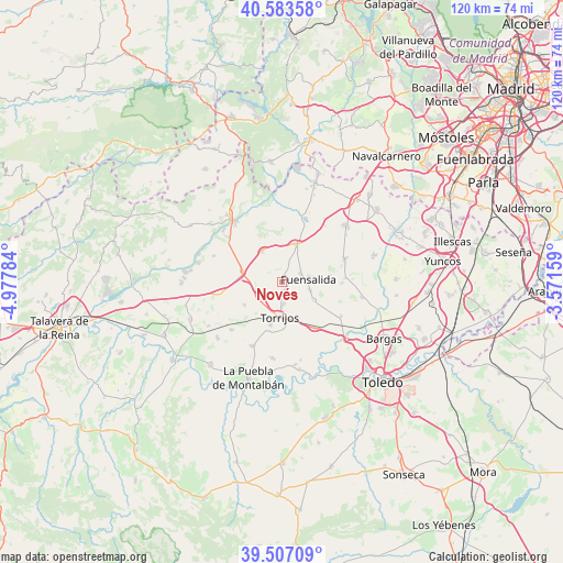
Novés GPS coordinates[2]
40° 2' 50.856" North, 4° 16' 28.956" West
| Map corner | latitude | longitude |
|---|---|---|
| Upper-left | 40.58358°, | -4.97784° |
| Center: | 40.04746°, | -4.27471° |
| Lower-right: | 39.50709°, | -3.57159° |
| Map W x H: | 119.7×119.7 km | = 74.4×74.4mi |
| max Lat: | 43.74134° ⇑69.6% North |
| Novés: | 40.04746° |
| min Lat: | ⇓30.4% South 27.64134° |
| min Long | Novés | max Long |
| -18.00367° | -4.27471° | 4.2899° |
| W 36.5%⇐ | ⇒63.5% E |
Elevation
Elevation of Novés is 555 m = 1821 ft, and this is 43 m = 141 ft below average elevation for this country.
| Max E: |
1682 m = 5518 ft | 57.7% |
| Avg. | 598 m = 1962 ft | |
| Novés | 555 m = 1821 ft | |
Min E: |
0 m = 0 ft | 42.3% |
See also: Spain elevation on elevation.city.
Geographical zone
Novés is located in North temperate zone (between Tropic of Cancer and the Arctic Circle). Distance of this Northern Tropic circle is 1846.9 km =1147.6 mi to South.| Distance of | km | miles | from Novés |
|---|---|---|---|
| North Pole | 5554.2 | 3451.2 | to North |
| Arctic Circle | 2948.3 | 1832 | to North |
| Tropic Cancer | 1846.9 | 1147.6 | to South |
| Equator | 4452.9 | 2766.9 | to South |


Nearby cities:
15 places around Novés: (largest is in red/bold)
• Alcabón
9.4 km =5.8 mi,  237°
237°
• Arcicóllar
13.5 km =8.4 mi,  86°
86°
• Barcience
7.9 km =4.9 mi,  154°
154°
• Camarena
14.2 km =8.8 mi,  69°
69°
• Fuensalida
5.8 km =3.6 mi,  84°
84°
• Gerindote
9.4 km =5.8 mi,  194°
194°
• Huecas
7.8 km =4.8 mi,  120°
120°
• La Torre de Esteban Hambrán
14.5 km =9 mi,  20°
20°
• Maqueda
8.4 km =5.2 mi,  284°
284°
• Portillo de Toledo
4.4 km =2.7 mi, 65°
• Quismondo
7.7 km =4.8 mi,  326°
326°
• Rielves
11.8 km =7.3 mi,  143°
143°
• Santa Cruz del Retamar
8.5 km =5.3 mi, 19°
• Santa Olalla
13.5 km =8.4 mi,  258°
258°
• Torrijos
7.3 km =4.5 mi, 185°
Sources, notices
• [Note1] Compared only with cities in Spain existing in our database
• [Src1] Map data: © OpenStreetMap contributors (CC-BY-SA)
• [Src2] Other city data from geonames.org with taken over terms of usage.
• [Src3] Geographical zone / Annual Mean Temperature by Robert A. Rohde @ Wikipedia
