Ruayer geodata
Ruayer (Asturias) is a populated place; located in Spain in Europe/Madrid (GMT+2) time zone. With population of 12,766 people, there are 713 cities with bigger population in this country. Compared to other cities in Spain, 94.9% of cities are located further ↓South; 79.4% of cities are located further →East and 72.9% of cities have lower elevation than Ruayer. Note1


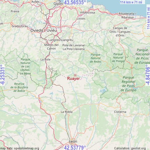
Ruayer GPS coordinates[2]
43° 3' 13.392" North, 5° 33' 0.684" West
| Map corner | latitude | longitude |
|---|---|---|
| Upper-left | 43.56535°, | -6.25331° |
| Center: | 43.05372°, | -5.55019° |
| Lower-right: | 42.53779°, | -4.84706° |
| Map W x H: | 114.3×114.3 km | = 71×71mi |
| max Lat: | 43.74134° ⇑5.1% North |
| Ruayer: | 43.05372° |
| min Lat: | ⇓94.9% South 27.64134° |
| min Long | Ruayer | max Long |
| -18.00367° | -5.55019° | 4.2899° |
| W 20.6%⇐ | ⇒79.4% E |
Elevation
Elevation of Ruayer is 834 m = 2736 ft, and this is 236 m = 774 ft above average elevation for this country.
| Max E: |
1682 m = 5518 ft | 27.1% |
| Ruayer | 834 m 2736 ft | |
| Avg. | 598 m = 1962 ft | |
Min E: |
0 m = 0 ft | 72.9% |
See also: Spain elevation on elevation.city.
Geographical zone
Ruayer is located in North temperate zone (between Tropic of Cancer and the Arctic Circle). Distance of this Northern Tropic circle is 2181.2 km =1355.3 mi to South.| Distance of | km | miles | from Ruayer |
|---|---|---|---|
| North Pole | 5219.9 | 3243.5 | to North |
| Arctic Circle | 2614 | 1624.3 | to North |
| Tropic Cancer | 2181.2 | 1355.3 | to South |
| Equator | 4787.1 | 2974.6 | to South |


Nearby cities:
15 places around Ruayer: (largest is in red/bold)
• Boñar
27.8 km =17.3 mi,  138°
138°
• Campo de Caso
22 km =13.7 mi,  49°
49°
• Cármenes
10.7 km =6.6 mi,  190°
190°
• El entrego
27 km =16.8 mi,  344°
344°
• La Pola de Gordón
23.9 km =14.9 mi,  203°
203°
• La Robla
28.6 km =17.8 mi, 192°
• Matallana de Torío
21.1 km =13.1 mi,  173°
173°
• Mieres
28 km =17.4 mi,  321°
321°
• Pola de Laviana
21.3 km =13.2 mi,  357°
357°
• Pola de Lena
25.6 km =15.9 mi,  297°
297°
• Puebla de Lillo
23.1 km =14.4 mi,  103°
103°
• Sama
29 km =18 mi, 338°
• Valdepiélago
24 km =14.9 mi,  148°
148°
• Vegacervera
18.5 km =11.5 mi,  176°
176°
• Villamanín
15.5 km =9.6 mi,  214°
214°
Sources, notices
• [Note1] Compared only with cities in Spain existing in our database
• [Src1] Map data: © OpenStreetMap contributors (CC-BY-SA)
• [Src2] Other city data from geonames.org with taken over terms of usage.
• [Src3] Geographical zone / Annual Mean Temperature by Robert A. Rohde @ Wikipedia
