Loranca de Tajuña geodata
Loranca de Tajuña (Castille-La Mancha) is a seat of a third-order administrative division; located in Spain in Europe/Madrid (GMT+2) time zone. With population of 711 people, there are 3386 cities with bigger population in this country. Compared to other cities in Spain, 63.1% of cities are located further ↑North; 52.6% of cities are located further ←West and 53.7% of cities have lower elevation than Loranca de Tajuña. Note1
Administrative division(s):
- Level 1: Castille-La Mancha
- Level 2: Provincia de Guadalajara
- Level 3: Loranca de Tajuña


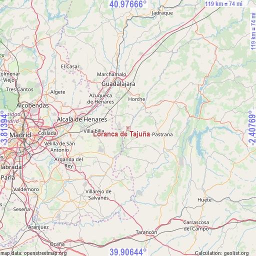
Loranca de Tajuña GPS coordinates[2]
40° 26' 37.248" North, 3° 6' 38.952" West
| Map corner | latitude | longitude |
|---|---|---|
| Upper-left | 40.97666°, | -3.81394° |
| Center: | 40.44368°, | -3.11082° |
| Lower-right: | 39.90644°, | -2.40769° |
| Map W x H: | 119×119 km | = 73.9×73.9mi |
| max Lat: | 43.74134° ⇑63.1% North |
| Loranca de Tajuña: | 40.44368° |
| min Lat: | ⇓36.9% South 27.64134° |
| min Long | Loranca de Taju | max Long |
| -18.00367° | -3.11082° | 4.2899° |
| W 52.6%⇐ | ⇒47.4% E |
Elevation
Elevation of Loranca de Tajuña is 697 m = 2287 ft, and this is 99 m = 325 ft above average elevation for this country.
| Max E: |
1682 m = 5518 ft | 46.3% |
| Loranca de Tajuña | 697 m 2287 ft | |
| Avg. | 598 m = 1962 ft | |
Min E: |
0 m = 0 ft | 53.7% |
See also: Spain elevation on elevation.city.
Geographical zone
Loranca de Tajuña is located in North temperate zone (between Tropic of Cancer and the Arctic Circle). Distance of this Northern Tropic circle is 1891 km =1175 mi to South.| Distance of | km | miles | from Loranca de Tajuña |
|---|---|---|---|
| North Pole | 5510.1 | 3423.8 | to North |
| Arctic Circle | 2904.3 | 1804.6 | to North |
| Tropic Cancer | 1891 | 1175 | to South |
| Equator | 4496.9 | 2794.2 | to South |


Nearby cities:
15 places around Loranca de Tajuña: (largest is in red/bold)
• Aranzueque
6.1 km =3.8 mi,  30°
30°
• Armuña de Tajuña
11.8 km =7.3 mi,  36°
36°
• Corpa
12.8 km =8 mi,  259°
259°
• Escariche
6.5 km =4 mi,  130°
130°
• Escopete
9.6 km =6 mi,  110°
110°
• Fuentenovilla
9.2 km =5.7 mi,  169°
169°
• Hontoba
6.2 km =3.9 mi,  79°
79°
• Hueva
12.9 km =8 mi, 80°
• Pezuela de las Torres
6.1 km =3.8 mi,  240°
240°
• Pioz
5.6 km =3.5 mi,  290°
290°
• Pozo de Guadalajara
8.3 km =5.2 mi,  313°
313°
• Renera
9.7 km =6 mi,  58°
58°
• Santorcaz
10.9 km =6.8 mi, 286°
• Valdarachas
8.3 km =5.2 mi,  350°
350°
• Yebes
9.8 km =6.1 mi,  1°
1°
Sources, notices
• [Note1] Compared only with cities in Spain existing in our database
• [Src1] Map data: © OpenStreetMap contributors (CC-BY-SA)
• [Src2] Other city data from geonames.org with taken over terms of usage.
• [Src3] Geographical zone / Annual Mean Temperature by Robert A. Rohde @ Wikipedia
