Chiprana geodata
Chiprana (Aragon) is a seat of a third-order administrative division; located in Spain in Europe/Madrid (GMT+2) time zone. With population of 355 people, there are 4297 cities with bigger population in this country. Compared to other cities in Spain, 54.6% of cities are located further ↓South; 86.2% of cities are located further ←West and 82.8% of cities have higher elevation than Chiprana. Note1


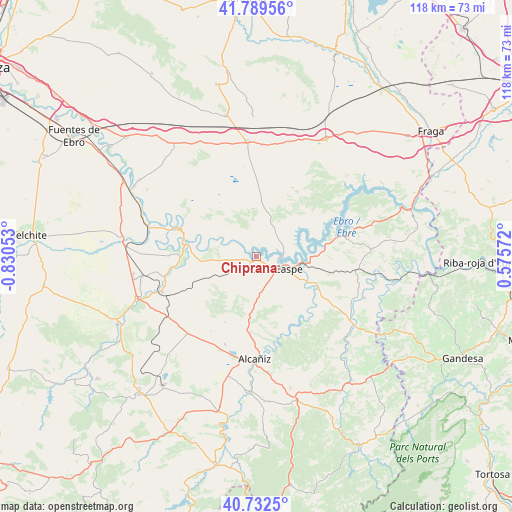
Chiprana GPS coordinates[2]
41° 15' 47.412" North, 0° 7' 38.676" West
| Map corner | latitude | longitude |
|---|---|---|
| Upper-left | 41.78956°, | -0.83053° |
| Center: | 41.26317°, | -0.12741° |
| Lower-right: | 40.7325°, | 0.57572° |
| Map W x H: | 117.5×117.5 km | = 73×73mi |
| max Lat: | 43.74134° ⇑45.4% North |
| Chiprana: | 41.26317° |
| min Lat: | ⇓54.6% South 27.64134° |
| min Long | Chiprana | max Long |
| -18.00367° | -0.12741° | 4.2899° |
| W 86.2%⇐ | ⇒13.8% E |
Elevation
Elevation of Chiprana is 171 m = 561 ft, and this is 427 m = 1401 ft below average elevation for this country.
| Max E: |
1682 m = 5518 ft | 82.8% |
| Avg. | 598 m = 1962 ft | |
| Chiprana | 171 m = 561 ft | |
Min E: |
0 m = 0 ft | 17.2% |
See also: Spain elevation on elevation.city.
Geographical zone
Chiprana is located in North temperate zone (between Tropic of Cancer and the Arctic Circle). Distance of this Northern Tropic circle is 1982.1 km =1231.6 mi to South.| Distance of | km | miles | from Chiprana |
|---|---|---|---|
| North Pole | 5419 | 3367.2 | to North |
| Arctic Circle | 2813.1 | 1748 | to North |
| Tropic Cancer | 1982.1 | 1231.6 | to South |
| Equator | 4588 | 2850.9 | to South |


Nearby cities:
15 places around Chiprana: (largest is in red/bold)
• Alborge
20.7 km =12.9 mi,  292°
292°
• Alcañiz
23.7 km =14.7 mi,  181°
181°
• Alforque
22.8 km =14.2 mi, 288°
• Bujaraloz
26.2 km =16.3 mi,  355°
355°
• Caspe
8 km =5 mi,  113°
113°
• Castelnou
20.2 km =12.6 mi,  259°
259°
• Cinco Olivas
22.1 km =13.7 mi, 292°
• Escatrón
16.7 km =10.4 mi,  280°
280°
• Fabara
26.6 km =16.5 mi, 111°
• Jatiel
21.8 km =13.5 mi, 257°
• La Puebla de Híjar
26.6 km =16.5 mi, 260°
• La Zaida
26.2 km =16.3 mi, 285°
• Maella
27.2 km =16.9 mi,  125°
125°
• Samper de Calanda
23.4 km =14.5 mi,  249°
249°
• Sástago
19.8 km =12.3 mi, 289°
Sources, notices
• [Note1] Compared only with cities in Spain existing in our database
• [Src1] Map data: © OpenStreetMap contributors (CC-BY-SA)
• [Src2] Other city data from geonames.org with taken over terms of usage.
• [Src3] Geographical zone / Annual Mean Temperature by Robert A. Rohde @ Wikipedia
