Pazuengos geodata
Pazuengos (La Rioja) is a seat of a third-order administrative division; located in Spain in Europe/Madrid (GMT+2) time zone. With population of 42 people, there are 6543 cities with bigger population in this country. Compared to other cities in Spain, 82.3% of cities are located further ↓South; 55.6% of cities are located further ←West and 95.7% of cities have lower elevation than Pazuengos. Note1


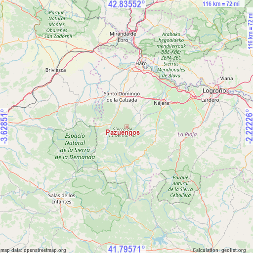
Pazuengos GPS coordinates[2]
42° 19' 3.936" North, 2° 55' 31.404" West
| Map corner | latitude | longitude |
|---|---|---|
| Upper-left | 42.83552°, | -3.62851° |
| Center: | 42.31776°, | -2.92539° |
| Lower-right: | 41.79571°, | -2.22226° |
| Map W x H: | 115.6×115.6 km | = 71.8×71.8mi |
| max Lat: | 43.74134° ⇑17.7% North |
| Pazuengos: | 42.31776° |
| min Lat: | ⇓82.3% South 27.64134° |
| min Long | Pazuengos | max Long |
| -18.00367° | -2.92539° | 4.2899° |
| W 55.6%⇐ | ⇒44.4% E |
Elevation
Elevation of Pazuengos is 1160 m = 3806 ft, and this is 562 m = 1844 ft above average elevation for this country.
| Max E: |
1682 m = 5518 ft | 4.3% |
| Pazuengos | 1160 m 3806 ft | |
| Avg. | 598 m = 1962 ft | |
Min E: |
0 m = 0 ft | 95.7% |
See also: Spain elevation on elevation.city.
Geographical zone
Pazuengos is located in North temperate zone (between Tropic of Cancer and the Arctic Circle). Distance of this Northern Tropic circle is 2099.4 km =1304.5 mi to South.| Distance of | km | miles | from Pazuengos |
|---|---|---|---|
| North Pole | 5301.8 | 3294.4 | to North |
| Arctic Circle | 2695.9 | 1675.2 | to North |
| Tropic Cancer | 2099.4 | 1304.5 | to South |
| Equator | 4705.3 | 2923.7 | to South |


Nearby cities:
15 places around Pazuengos: (largest is in red/bold)
• Badarán
10.9 km =6.8 mi,  59°
59°
• Berceo
6.5 km =4 mi,  68°
68°
• Cañas
10.5 km =6.5 mi,  37°
37°
• Cirueña
10.8 km =6.7 mi,  12°
12°
• Estollo
6.3 km =3.9 mi,  77°
77°
• Ezcaray
7.3 km =4.5 mi,  276°
276°
• Manzanares de Rioja
9 km =5.6 mi,  15°
15°
• Ojacastro
7.3 km =4.5 mi,  296°
296°
• San Millán de la Cogolla
5.4 km =3.4 mi, 75°
• Santurdejo
7 km =4.3 mi,  340°
340°
• Tobía
9.4 km =5.8 mi,  103°
103°
• Villar de Torre
7.8 km =4.8 mi, 40°
• Villarejo
7 km =4.3 mi,  26°
26°
• Villaverde de Rioja
9.2 km =5.7 mi,  88°
88°
• Zorraquín
9.4 km =5.8 mi, 275°
Sources, notices
• [Note1] Compared only with cities in Spain existing in our database
• [Src1] Map data: © OpenStreetMap contributors (CC-BY-SA)
• [Src2] Other city data from geonames.org with taken over terms of usage.
• [Src3] Geographical zone / Annual Mean Temperature by Robert A. Rohde @ Wikipedia
