Ojacastro geodata
Ojacastro (La Rioja) is a seat of a third-order administrative division; located in Spain in Europe/Madrid (GMT+2) time zone. With population of 218 people, there are 4933 cities with bigger population in this country. Compared to other cities in Spain, 83.3% of cities are located further ↓South; 54.4% of cities are located further ←West and 66.8% of cities have lower elevation than Ojacastro. Note1


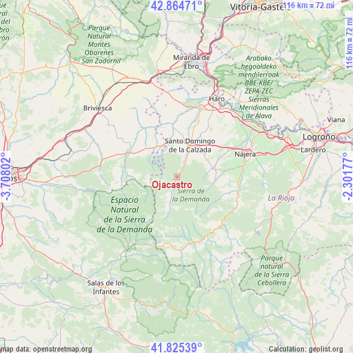
Ojacastro GPS coordinates[2]
42° 20' 49.92" North, 3° 0' 17.64" West
| Map corner | latitude | longitude |
|---|---|---|
| Upper-left | 42.86471°, | -3.70802° |
| Center: | 42.3472°, | -3.0049° |
| Lower-right: | 41.82539°, | -2.30177° |
| Map W x H: | 115.6×115.6 km | = 71.8×71.8mi |
| max Lat: | 43.74134° ⇑16.7% North |
| Ojacastro: | 42.3472° |
| min Lat: | ⇓83.3% South 27.64134° |
| min Long | Ojacastro | max Long |
| -18.00367° | -3.0049° | 4.2899° |
| W 54.4%⇐ | ⇒45.6% E |
Elevation
Elevation of Ojacastro is 790 m = 2592 ft, and this is 192 m = 630 ft above average elevation for this country.
| Max E: |
1682 m = 5518 ft | 33.2% |
| Ojacastro | 790 m 2592 ft | |
| Avg. | 598 m = 1962 ft | |
Min E: |
0 m = 0 ft | 66.8% |
See also: Spain elevation on elevation.city.
Geographical zone
Ojacastro is located in North temperate zone (between Tropic of Cancer and the Arctic Circle). Distance of this Northern Tropic circle is 2102.6 km =1306.5 mi to South.| Distance of | km | miles | from Ojacastro |
|---|---|---|---|
| North Pole | 5298.5 | 3292.3 | to North |
| Arctic Circle | 2692.6 | 1673.1 | to North |
| Tropic Cancer | 2102.6 | 1306.5 | to South |
| Equator | 4708.6 | 2925.8 | to South |


Nearby cities:
15 places around Ojacastro: (largest is in red/bold)
• Bascuñana
10.8 km =6.7 mi,  323°
323°
• Cirueña
11.5 km =7.1 mi,  51°
51°
• Corporales
9.5 km =5.9 mi,  4°
4°
• Ezcaray
2.5 km =1.6 mi,  195°
195°
• Fresneda de la Sierra Tirón
11.3 km =7 mi,  251°
251°
• Grañón
11.6 km =7.2 mi,  350°
350°
• Manzanares de Rioja
10.5 km =6.5 mi,  58°
58°
• Pazuengos
7.3 km =4.5 mi,  116°
116°
• Redecilla del Camino
11.3 km =7 mi,  333°
333°
• Santo Domingo de la Calzada
11.2 km =7 mi,  22°
22°
• Santurdejo
5.3 km =3.3 mi, 51°
• Valgañón
6.1 km =3.8 mi,  237°
237°
• Villarejo
10.1 km =6.3 mi,  72°
72°
• Villarta-Quintana
9.9 km =6.2 mi,  338°
338°
• Zorraquín
3.7 km =2.3 mi,  229°
229°
Sources, notices
• [Note1] Compared only with cities in Spain existing in our database
• [Src1] Map data: © OpenStreetMap contributors (CC-BY-SA)
• [Src2] Other city data from geonames.org with taken over terms of usage.
• [Src3] Geographical zone / Annual Mean Temperature by Robert A. Rohde @ Wikipedia
