Palazuelos de Eresma geodata
Palazuelos de Eresma (Castille and León) is a seat of a third-order administrative division; located in Spain in Europe/Madrid (GMT+2) time zone. With population of 2,751 people, there are 1801 cities with bigger population in this country. Compared to other cities in Spain, 53.2% of cities are located further ↑North; 60.7% of cities are located further →East and 92.6% of cities have lower elevation than Palazuelos de Eresma. Note1
Administrative division(s):
- Level 1: Castille and León
- Level 2: Provincia de Segovia
- Level 3: Palazuelos de Eresma


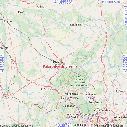
Palazuelos de Eresma GPS coordinates[2]
40° 55' 49.98" North, 4° 3' 38.556" West
| Map corner | latitude | longitude |
|---|---|---|
| Upper-left | 41.45963°, | -4.76384° |
| Center: | 40.93055°, | -4.06071° |
| Lower-right: | 40.3972°, | -3.35759° |
| Map W x H: | 118.1×118.1 km | = 73.4×73.4mi |
| max Lat: | 43.74134° ⇑53.2% North |
| Palazuelos de Eresma: | 40.93055° |
| min Lat: | ⇓46.8% South 27.64134° |
| min Long | Palazuelos de E | max Long |
| -18.00367° | -4.06071° | 4.2899° |
| W 39.3%⇐ | ⇒60.7% E |
Elevation
Elevation of Palazuelos de Eresma is 1084 m = 3556 ft, and this is 486 m = 1594 ft above average elevation for this country.
| Max E: |
1682 m = 5518 ft | 7.4% |
| Palazuelos de Eresma | 1084 m 3556 ft | |
| Avg. | 598 m = 1962 ft | |
Min E: |
0 m = 0 ft | 92.6% |
See also: Spain elevation on elevation.city.
Geographical zone
Palazuelos de Eresma is located in North temperate zone (between Tropic of Cancer and the Arctic Circle). Distance of this Northern Tropic circle is 1945.1 km =1208.6 mi to South.| Distance of | km | miles | from Palazuelos de Eresma |
|---|---|---|---|
| North Pole | 5456 | 3390.2 | to North |
| Arctic Circle | 2850.1 | 1771 | to North |
| Tropic Cancer | 1945.1 | 1208.6 | to South |
| Equator | 4551.1 | 2827.9 | to South |


Nearby cities:
15 places around Palazuelos de Eresma: (largest is in red/bold)
• Adrada de Pirón
13.6 km =8.5 mi,  3°
3°
• Basardilla
11.2 km =7 mi,  15°
15°
• Brieva
11.6 km =7.2 mi, 2°
• Encinillas
12.7 km =7.9 mi,  320°
320°
• Espirdo
7.5 km =4.7 mi,  351°
351°
• Hontanares de Eresma
13.4 km =8.3 mi,  295°
295°
• La Lastrilla
5.6 km =3.5 mi, 318°
• Ortigosa del Monte
13.9 km =8.6 mi,  224°
224°
• San Cristóbal de Segovia
2.8 km =1.7 mi,  331°
331°
• San Ildefonso
5.5 km =3.4 mi,  125°
125°
• Santo Domingo de Pirón
13.7 km =8.5 mi,  25°
25°
• Segovia
5.2 km =3.2 mi,  291°
291°
• Torrecaballeros
7.5 km =4.7 mi, 23°
• Trescasas
4.3 km =2.7 mi, 28°
• Valseca
12.3 km =7.6 mi,  308°
308°
Sources, notices
• [Note1] Compared only with cities in Spain existing in our database
• [Src1] Map data: © OpenStreetMap contributors (CC-BY-SA)
• [Src2] Other city data from geonames.org with taken over terms of usage.
• [Src3] Geographical zone / Annual Mean Temperature by Robert A. Rohde @ Wikipedia
