San Ildefonso geodata
San Ildefonso (Castille and León) is a seat of a third-order administrative division; located in Spain in Europe/Madrid (GMT+2) time zone. With population of 5,426 people, there are 1227 cities with bigger population in this country. Compared to other cities in Spain, 53.8% of cities are located further ↑North; 59.8% of cities are located further →East and 95.9% of cities have lower elevation than San Ildefonso. Note1
Administrative division(s):
- Level 1: Castille and León
- Level 2: Provincia de Segovia
- Level 3: Real Sitio de San Ildefonso


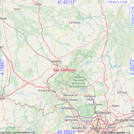
San Ildefonso GPS coordinates[2]
40° 54' 6.552" North, 4° 0' 24.66" West
| Map corner | latitude | longitude |
|---|---|---|
| Upper-left | 41.43113°, | -4.70997° |
| Center: | 40.90182°, | -4.00685° |
| Lower-right: | 40.36824°, | -3.30372° |
| Map W x H: | 118.2×118.2 km | = 73.4×73.4mi |
| max Lat: | 43.74134° ⇑53.8% North |
| San Ildefonso: | 40.90182° |
| min Lat: | ⇓46.2% South 27.64134° |
| min Long | San Ildefonso | max Long |
| -18.00367° | -4.00685° | 4.2899° |
| W 40.2%⇐ | ⇒59.8% E |
Elevation
Elevation of San Ildefonso is 1166 m = 3825 ft, and this is 568 m = 1864 ft above average elevation for this country.
| Max E: |
1682 m = 5518 ft | 4.1% |
| San Ildefonso | 1166 m 3825 ft | |
| Avg. | 598 m = 1962 ft | |
Min E: |
0 m = 0 ft | 95.9% |
See also: Spain elevation on elevation.city.
Geographical zone
San Ildefonso is located in North temperate zone (between Tropic of Cancer and the Arctic Circle). Distance of this Northern Tropic circle is 1941.9 km =1206.6 mi to South.| Distance of | km | miles | from San Ildefonso |
|---|---|---|---|
| North Pole | 5459.2 | 3392.2 | to North |
| Arctic Circle | 2853.3 | 1773 | to North |
| Tropic Cancer | 1941.9 | 1206.6 | to South |
| Equator | 4547.9 | 2825.9 | to South |


Nearby cities:
15 places around San Ildefonso: (largest is in red/bold)
• Alameda del Valle
13.9 km =8.6 mi,  82°
82°
• Basardilla
14.1 km =8.8 mi,  353°
353°
• Brieva
15.3 km =9.5 mi, 345°
• Espirdo
12 km =7.5 mi,  332°
332°
• La Lastrilla
11 km =6.8 mi,  311°
311°
• Ortigosa del Monte
15.8 km =9.8 mi,  245°
245°
• Palazuelos de Eresma
5.5 km =3.4 mi, 305°
• Pinilla del Valle
16.2 km =10.1 mi, 81°
• Rascafría
10.7 km =6.6 mi,  88°
88°
• San Cristóbal de Segovia
8.1 km =5 mi, 313°
• Santo Domingo de Pirón
15.5 km =9.6 mi,  5°
5°
• Segovia
10.7 km =6.6 mi,  298°
298°
• Sotosalbos
15.8 km =9.8 mi,  20°
20°
• Torrecaballeros
10.2 km =6.3 mi, 351°
• Trescasas
7.4 km =4.6 mi,  340°
340°
In other languages:
- In Spanish: La Granja de San Ildefonso
- In France: Real Sitio de San Ildefonso
- In Russian: Сан-Ильдефонсо
- In Chinese: 圣伊尔德丰索
Sources, notices
• [Note1] Compared only with cities in Spain existing in our database
• [Src1] Map data: © OpenStreetMap contributors (CC-BY-SA)
• [Src2] Other city data from geonames.org with taken over terms of usage.
• [Src3] Geographical zone / Annual Mean Temperature by Robert A. Rohde @ Wikipedia
