Orkoien geodata
Orkoien (Navarre) is a populated place; located in Spain in Europe/Madrid (GMT+2) time zone. With population of 2,087 people, there are 2106 cities with bigger population in this country. Compared to other cities in Spain, 92.9% of cities are located further ↓South; 70.5% of cities are located further ←West and 66.1% of cities have higher elevation than Orkoien. Note1
Administrative division(s):
- Level 1: Navarre
- Level 2: Provincia de Navarra
- Level 3: Cendea de Olza/Oltza Zendea


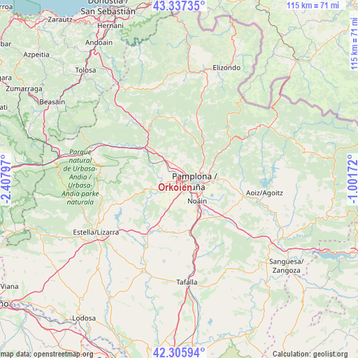
Orkoien GPS coordinates[2]
42° 49' 25.68" North, 1° 42' 17.46" West
| Map corner | latitude | longitude |
|---|---|---|
| Upper-left | 43.33735°, | -2.40797° |
| Center: | 42.8238°, | -1.70485° |
| Lower-right: | 42.30594°, | -1.00172° |
| Map W x H: | 114.7×114.7 km | = 71.3×71.3mi |
| max Lat: | 43.74134° ⇑7.1% North |
| Orkoien: | 42.8238° |
| min Lat: | ⇓92.9% South 27.64134° |
| min Long | Orkoien | max Long |
| -18.00367° | -1.70485° | 4.2899° |
| W 70.5%⇐ | ⇒29.5% E |
Elevation
Elevation of Orkoien is 445 m = 1460 ft, and this is 153 m = 502 ft below average elevation for this country.
| Max E: |
1682 m = 5518 ft | 66.1% |
| Avg. | 598 m = 1962 ft | |
| Orkoien | 445 m = 1460 ft | |
Min E: |
0 m = 0 ft | 33.9% |
See also: Spain elevation on elevation.city.
Geographical zone
Orkoien is located in North temperate zone (between Tropic of Cancer and the Arctic Circle). Distance of this Northern Tropic circle is 2155.6 km =1339.4 mi to South.| Distance of | km | miles | from Orkoien |
|---|---|---|---|
| North Pole | 5245.5 | 3259.4 | to North |
| Arctic Circle | 2639.6 | 1640.2 | to North |
| Tropic Cancer | 2155.6 | 1339.4 | to South |
| Equator | 4761.6 | 2958.7 | to South |


Nearby cities:
15 places around Orkoien: (largest is in red/bold)
• Atarrabia
8 km =5 mi,  83°
83°
• Barañáin
3 km =1.9 mi,  131°
131°
• Berriobeiti
2.9 km =1.8 mi,  7°
7°
• Berriozar
3.2 km =2 mi, 76°
• Burlata
7.2 km =4.5 mi,  88°
88°
• Cizur Mayor
4.2 km =2.6 mi,  163°
163°
• Ermitagaña
3.6 km =2.2 mi,  113°
113°
• Galar
6.9 km =4.3 mi,  175°
175°
• Iturrama
4.2 km =2.6 mi, 114°
• Itza
2.5 km =1.6 mi,  305°
305°
• Oltza
5.8 km =3.6 mi,  300°
300°
• Pamplona
5.1 km =3.2 mi,  98°
98°
• Primer Ensanche
4.7 km =2.9 mi, 102°
• Sarriguren
8.8 km =5.5 mi, 97°
• Segundo Ensanche
5.2 km =3.2 mi, 102°
Sources, notices
• [Note1] Compared only with cities in Spain existing in our database
• [Src1] Map data: © OpenStreetMap contributors (CC-BY-SA)
• [Src2] Other city data from geonames.org with taken over terms of usage.
• [Src3] Geographical zone / Annual Mean Temperature by Robert A. Rohde @ Wikipedia
