Ermitagaña geodata
Ermitagaña (Navarre) is a populated place; located in Spain in Europe/Madrid (GMT+2) time zone. With population of 17,163 people, there are 549 cities with bigger population in this country. Compared to other cities in Spain, 92.8% of cities are located further ↓South; 71.2% of cities are located further ←West and 66.1% of cities have higher elevation than Ermitagaña. Note1


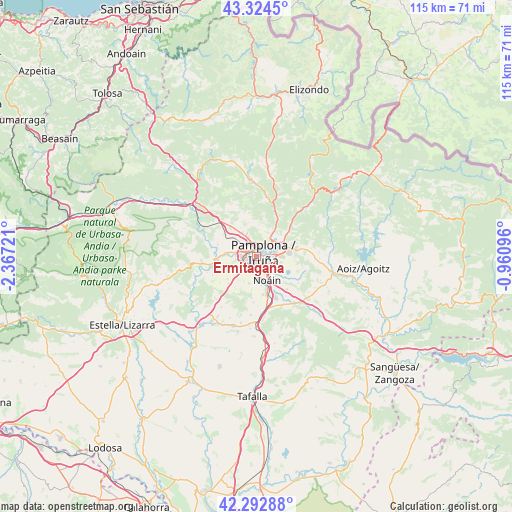
Ermitagaña GPS coordinates[2]
42° 48' 39.024" North, 1° 39' 50.724" West
| Map corner | latitude | longitude |
|---|---|---|
| Upper-left | 43.3245°, | -2.36721° |
| Center: | 42.81084°, | -1.66409° |
| Lower-right: | 42.29288°, | -0.96096° |
| Map W x H: | 114.7×114.7 km | = 71.3×71.3mi |
| max Lat: | 43.74134° ⇑7.2% North |
| Ermitagaña: | 42.81084° |
| min Lat: | ⇓92.8% South 27.64134° |
| min Long | Ermitagaña | max Long |
| -18.00367° | -1.66409° | 4.2899° |
| W 71.2%⇐ | ⇒28.8% E |
Elevation
Elevation of Ermitagaña is 445 m = 1460 ft, and this is 153 m = 502 ft below average elevation for this country.
| Max E: |
1682 m = 5518 ft | 66.1% |
| Avg. | 598 m = 1962 ft | |
| Ermitagaña | 445 m = 1460 ft | |
Min E: |
0 m = 0 ft | 33.9% |
See also: Spain elevation on elevation.city.
Geographical zone
Ermitagaña is located in North temperate zone (between Tropic of Cancer and the Arctic Circle). Distance of this Northern Tropic circle is 2154.2 km =1338.6 mi to South.| Distance of | km | miles | from Ermitagaña |
|---|---|---|---|
| North Pole | 5246.9 | 3260.3 | to North |
| Arctic Circle | 2641.1 | 1641.1 | to North |
| Tropic Cancer | 2154.2 | 1338.6 | to South |
| Equator | 4760.1 | 2957.8 | to South |


Nearby cities:
15 places around Ermitagaña: (largest is in red/bold)
• Atarrabia
5.2 km =3.2 mi,  62°
62°
• Barañáin
1.2 km =0.7 mi,  241°
241°
• Berriobeiti
5.2 km =3.2 mi,  326°
326°
• Berriozar
2.2 km =1.4 mi,  354°
354°
• Burlata
4.2 km =2.6 mi,  66°
66°
• Cizur Mayor
3.3 km =2.1 mi,  220°
220°
• Galar
6.2 km =3.9 mi,  207°
207°
• Huarte-Uharte
6.4 km =4 mi, 70°
• Iturrama
0.5 km =0.3 mi,  118°
118°
• Itza
6 km =3.7 mi,  298°
298°
• Orkoien
3.6 km =2.2 mi,  293°
293°
• Pamplona
1.8 km =1.1 mi, 68°
• Primer Ensanche
1.3 km =0.8 mi, 70°
• Sarriguren
5.4 km =3.4 mi,  87°
87°
• Segundo Ensanche
1.8 km =1.1 mi,  78°
78°
Sources, notices
• [Note1] Compared only with cities in Spain existing in our database
• [Src1] Map data: © OpenStreetMap contributors (CC-BY-SA)
• [Src2] Other city data from geonames.org with taken over terms of usage.
• [Src3] Geographical zone / Annual Mean Temperature by Robert A. Rohde @ Wikipedia
