Elorrio geodata
Elorrio (Basque Country) is a seat of a third-order administrative division; located in Spain in Europe/Madrid (GMT+2) time zone. With population of 7,041 people, there are 1034 cities with bigger population in this country. Compared to other cities in Spain, 95.5% of cities are located further ↓South; 60.5% of cities are located further ←West and 81.7% of cities have higher elevation than Elorrio. Note1


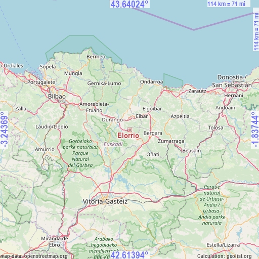
Elorrio GPS coordinates[2]
43° 7' 45.264" North, 2° 32' 26.016" West
| Map corner | latitude | longitude |
|---|---|---|
| Upper-left | 43.64024°, | -3.24369° |
| Center: | 43.12924°, | -2.54056° |
| Lower-right: | 42.61394°, | -1.83744° |
| Map W x H: | 114.1×114.1 km | = 70.9×70.9mi |
| max Lat: | 43.74134° ⇑4.5% North |
| Elorrio: | 43.12924° |
| min Lat: | ⇓95.5% South 27.64134° |
| min Long | Elorrio | max Long |
| -18.00367° | -2.54056° | 4.2899° |
| W 60.5%⇐ | ⇒39.5% E |
Elevation
Elevation of Elorrio is 192 m = 630 ft, and this is 406 m = 1332 ft below average elevation for this country.
| Max E: |
1682 m = 5518 ft | 81.7% |
| Avg. | 598 m = 1962 ft | |
| Elorrio | 192 m = 630 ft | |
Min E: |
0 m = 0 ft | 18.3% |
See also: Spain elevation on elevation.city.
Geographical zone
Elorrio is located in North temperate zone (between Tropic of Cancer and the Arctic Circle). Distance of this Northern Tropic circle is 2189.6 km =1360.6 mi to South.| Distance of | km | miles | from Elorrio |
|---|---|---|---|
| North Pole | 5211.5 | 3238.3 | to North |
| Arctic Circle | 2605.7 | 1619.1 | to North |
| Tropic Cancer | 2189.6 | 1360.6 | to South |
| Equator | 4795.5 | 2979.8 | to South |


Nearby cities:
15 places around Elorrio: (largest is in red/bold)
• Abadiño
6.1 km =3.8 mi,  293°
293°
• Antzuola
13.5 km =8.4 mi,  105°
105°
• Aretxabaleta
11 km =6.8 mi,  164°
164°
• Arrasate / Mondragón
8.3 km =5.2 mi,  150°
150°
• Bergara
10.1 km =6.3 mi,  98°
98°
• Berriz
4.7 km =2.9 mi,  333°
333°
• Durango
8.9 km =5.5 mi,  301°
301°
• Eibar
8.3 km =5.2 mi,  42°
42°
• Elgeta
4.3 km =2.7 mi,  78°
78°
• Ermua
7.1 km =4.4 mi,  25°
25°
• Eskoriatza
12.4 km =7.7 mi,  174°
174°
• Iurreta
9.6 km =6 mi,  308°
308°
• Izurtza
7.9 km =4.9 mi, 287°
• Mañaria
9.8 km =6.1 mi,  275°
275°
• Zaldibar
4.2 km =2.6 mi,  8°
8°
Sources, notices
• [Note1] Compared only with cities in Spain existing in our database
• [Src1] Map data: © OpenStreetMap contributors (CC-BY-SA)
• [Src2] Other city data from geonames.org with taken over terms of usage.
• [Src3] Geographical zone / Annual Mean Temperature by Robert A. Rohde @ Wikipedia
