Velilla de los Ajos geodata
Velilla de los Ajos (Castille and León) is a seat of a third-order administrative division; located in Spain in Europe/Madrid (GMT+2) time zone. With population of 40 people, there are 6570 cities with bigger population in this country. Compared to other cities in Spain, 60.6% of cities are located further ↓South; 64.1% of cities are located further ←West and 88.8% of cities have lower elevation than Velilla de los Ajos. Note1
Administrative division(s):
- Level 1: Castille and León
- Level 2: Provincia de Soria
- Level 3: Velilla de los Ajos


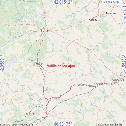
Velilla de los Ajos GPS coordinates[2]
41° 29' 26.088" North, 2° 15' 20.844" West
| Map corner | latitude | longitude |
|---|---|---|
| Upper-left | 42.01512°, | -2.95891° |
| Center: | 41.49058°, | -2.25579° |
| Lower-right: | 40.96175°, | -1.55266° |
| Map W x H: | 117.1×117.1 km | = 72.8×72.8mi |
| max Lat: | 43.74134° ⇑39.4% North |
| Velilla de los Ajos: | 41.49058° |
| min Lat: | ⇓60.6% South 27.64134° |
| min Long | Velilla de los | max Long |
| -18.00367° | -2.25579° | 4.2899° |
| W 64.1%⇐ | ⇒35.9% E |
Elevation
Elevation of Velilla de los Ajos is 1010 m = 3314 ft, and this is 412 m = 1352 ft above average elevation for this country.
| Max E: |
1682 m = 5518 ft | 11.2% |
| Velilla de los Ajos | 1010 m 3314 ft | |
| Avg. | 598 m = 1962 ft | |
Min E: |
0 m = 0 ft | 88.8% |
See also: Spain elevation on elevation.city.
Geographical zone
Velilla de los Ajos is located in North temperate zone (between Tropic of Cancer and the Arctic Circle). Distance of this Northern Tropic circle is 2007.4 km =1247.3 mi to South.| Distance of | km | miles | from Velilla de los Ajos |
|---|---|---|---|
| North Pole | 5393.7 | 3351.5 | to North |
| Arctic Circle | 2787.9 | 1732.3 | to North |
| Tropic Cancer | 2007.4 | 1247.3 | to South |
| Equator | 4613.3 | 2866.6 | to South |


Nearby cities:
15 places around Velilla de los Ajos: (largest is in red/bold)
• Alentisque
10 km =6.2 mi,  219°
219°
• Almazul
13 km =8.1 mi,  44°
44°
• Bliecos
4.3 km =2.7 mi,  342°
342°
• Borjabad
11.5 km =7.1 mi,  306°
306°
• Cañamaque
5.3 km =3.3 mi,  163°
163°
• Escobosa de Almazán
9.6 km =6 mi,  267°
267°
• Gómara
15 km =9.3 mi,  9°
9°
• Maján
4.6 km =2.9 mi,  238°
238°
• Momblona
9.2 km =5.7 mi, 235°
• Monteagudo de las Vicarías
15.7 km =9.8 mi,  152°
152°
• Nepas
12.5 km =7.8 mi,  288°
288°
• Nolay
8.9 km =5.5 mi,  297°
297°
• Soliedra
10.7 km =6.6 mi,  257°
257°
• Tejado
11 km =6.8 mi,  355°
355°
• Torlengua
8.8 km =5.5 mi,  116°
116°
Sources, notices
• [Note1] Compared only with cities in Spain existing in our database
• [Src1] Map data: © OpenStreetMap contributors (CC-BY-SA)
• [Src2] Other city data from geonames.org with taken over terms of usage.
• [Src3] Geographical zone / Annual Mean Temperature by Robert A. Rohde @ Wikipedia
