Tejado geodata
Tejado (Castille and León) is a seat of a third-order administrative division; located in Spain in Europe/Madrid (GMT+2) time zone. With population of 184 people, there are 5155 cities with bigger population in this country. Compared to other cities in Spain, 63.1% of cities are located further ↓South; 63.9% of cities are located further ←West and 87.5% of cities have lower elevation than Tejado. Note1


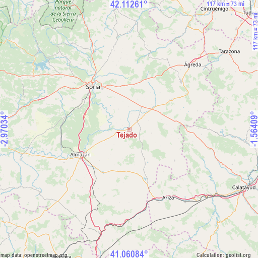
Tejado GPS coordinates[2]
41° 35' 19.932" North, 2° 16' 1.956" West
| Map corner | latitude | longitude |
|---|---|---|
| Upper-left | 42.11261°, | -2.97034° |
| Center: | 41.58887°, | -2.26721° |
| Lower-right: | 41.06084°, | -1.56409° |
| Map W x H: | 116.9×116.9 km | = 72.6×72.6mi |
| max Lat: | 43.74134° ⇑36.9% North |
| Tejado: | 41.58887° |
| min Lat: | ⇓63.1% South 27.64134° |
| min Long | Tejado | max Long |
| -18.00367° | -2.26721° | 4.2899° |
| W 63.9%⇐ | ⇒36.1% E |
Elevation
Elevation of Tejado is 989 m = 3245 ft, and this is 391 m = 1283 ft above average elevation for this country.
| Max E: |
1682 m = 5518 ft | 12.5% |
| Tejado | 989 m 3245 ft | |
| Avg. | 598 m = 1962 ft | |
Min E: |
0 m = 0 ft | 87.5% |
See also: Spain elevation on elevation.city.
Geographical zone
Tejado is located in North temperate zone (between Tropic of Cancer and the Arctic Circle). Distance of this Northern Tropic circle is 2018.3 km =1254.1 mi to South.| Distance of | km | miles | from Tejado |
|---|---|---|---|
| North Pole | 5382.8 | 3344.7 | to North |
| Arctic Circle | 2776.9 | 1725.5 | to North |
| Tropic Cancer | 2018.3 | 1254.1 | to South |
| Equator | 4624.2 | 2873.3 | to South |


Nearby cities:
15 places around Tejado: (largest is in red/bold)
• Aldealafuente
10.4 km =6.5 mi,  332°
332°
• Aliud
7.3 km =4.5 mi,  9°
9°
• Almazul
10.2 km =6.3 mi,  99°
99°
• Almenar de Soria
11.8 km =7.3 mi,  27°
27°
• Bliecos
6.8 km =4.2 mi,  182°
182°
• Borjabad
9.2 km =5.7 mi,  243°
243°
• Buberos
8.9 km =5.5 mi,  43°
43°
• Cabrejas del Campo
10.2 km =6.3 mi,  358°
358°
• Candilichera
13.1 km =8.1 mi,  347°
347°
• Cubo de la Solana
12.9 km =8 mi,  276°
276°
• Gómara
5.2 km =3.2 mi, 42°
• Nepas
13 km =8.1 mi, 237°
• Nolay
9.8 km =6.1 mi,  225°
225°
• Velilla de los Ajos
11 km =6.8 mi, 175°
• Villaseca de Arciel
9.6 km =6 mi,  65°
65°
Sources, notices
• [Note1] Compared only with cities in Spain existing in our database
• [Src1] Map data: © OpenStreetMap contributors (CC-BY-SA)
• [Src2] Other city data from geonames.org with taken over terms of usage.
• [Src3] Geographical zone / Annual Mean Temperature by Robert A. Rohde @ Wikipedia
