Vilalba geodata
Vilalba (Galicia) is a seat of a third-order administrative division; located in Spain in Europe/Madrid (GMT+2) time zone. With population of 15,437 people, there are 605 cities with bigger population in this country. Compared to other cities in Spain, 97.5% of cities are located further ↓South; 95.7% of cities are located further →East and 63.6% of cities have higher elevation than Vilalba. Note1


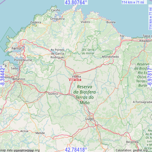
Vilalba GPS coordinates[2]
43° 17' 53.016" North, 7° 40' 52.68" West
| Map corner | latitude | longitude |
|---|---|---|
| Upper-left | 43.80764°, | -8.38442° |
| Center: | 43.29806°, | -7.6813° |
| Lower-right: | 42.78418°, | -6.97817° |
| Map W x H: | 113.8×113.8 km | = 70.7×70.7mi |
| max Lat: | 43.74134° ⇑2.5% North |
| Vilalba: | 43.29806° |
| min Lat: | ⇓97.5% South 27.64134° |
| min Long | Vilalba | max Long |
| -18.00367° | -7.6813° | 4.2899° |
| W 4.3%⇐ | ⇒95.7% E |
Elevation
Elevation of Vilalba is 478 m = 1568 ft, and this is 120 m = 394 ft below average elevation for this country.
| Max E: |
1682 m = 5518 ft | 63.6% |
| Avg. | 598 m = 1962 ft | |
| Vilalba | 478 m = 1568 ft | |
Min E: |
0 m = 0 ft | 36.4% |
See also: Spain elevation on elevation.city.
Geographical zone
Vilalba is located in North temperate zone (between Tropic of Cancer and the Arctic Circle). Distance of this Northern Tropic circle is 2208.4 km =1372.2 mi to South.| Distance of | km | miles | from Vilalba |
|---|---|---|---|
| North Pole | 5192.8 | 3226.7 | to North |
| Arctic Circle | 2586.9 | 1607.4 | to North |
| Tropic Cancer | 2208.4 | 1372.2 | to South |
| Equator | 4814.3 | 2991.5 | to South |


Nearby cities:
15 places around Vilalba: (largest is in red/bold)
• Abadín
17.7 km =11 mi,  64°
64°
• Aranga
28.1 km =17.5 mi,  255°
255°
• As Pontes de García Rodríguez
22 km =13.7 mi,  321°
321°
• Begonte
16.3 km =10.1 mi,  181°
181°
• Castro de Rei
24.8 km =15.4 mi,  113°
113°
• Friol
31 km =19.3 mi,  197°
197°
• Guitiriz
21.7 km =13.5 mi,  233°
233°
• Irixoa
30.6 km =19 mi,  267°
267°
• Mondoñedo
25.4 km =15.8 mi, 63°
• Mondoñedo
29.8 km =18.5 mi, 61°
• Monfero
27.4 km =17 mi,  278°
278°
• Mos
19 km =11.8 mi,  146°
146°
• Muras
19.1 km =11.9 mi,  349°
349°
• Outeiro de Rei
22.5 km =14 mi,  166°
166°
• Rábade
20.8 km =12.9 mi, 165°
Sources, notices
• [Note1] Compared only with cities in Spain existing in our database
• [Src1] Map data: © OpenStreetMap contributors (CC-BY-SA)
• [Src2] Other city data from geonames.org with taken over terms of usage.
• [Src3] Geographical zone / Annual Mean Temperature by Robert A. Rohde @ Wikipedia
