Morés geodata
Morés (Aragon) is a seat of a third-order administrative division; located in Spain in Europe/Madrid (GMT+2) time zone. With population of 413 people, there are 4102 cities with bigger population in this country. Compared to other cities in Spain, 60.1% of cities are located further ↓South; 72.3% of cities are located further ←West and 65.8% of cities have higher elevation than Morés. Note1


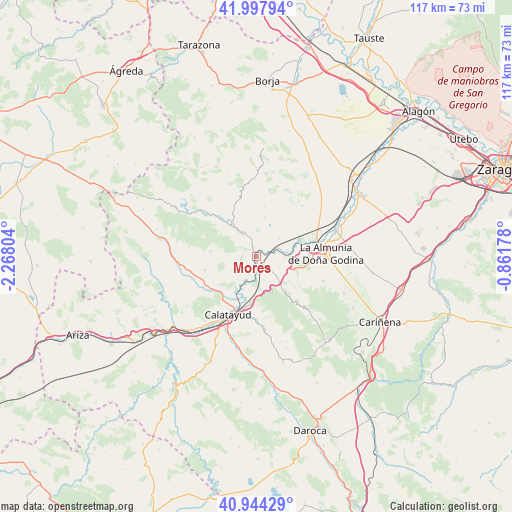
Morés GPS coordinates[2]
41° 28' 23.736" North, 1° 33' 53.676" West
| Map corner | latitude | longitude |
|---|---|---|
| Upper-left | 41.99794°, | -2.26804° |
| Center: | 41.47326°, | -1.56491° |
| Lower-right: | 40.94429°, | -0.86178° |
| Map W x H: | 117.2×117.2 km | = 72.8×72.8mi |
| max Lat: | 43.74134° ⇑39.9% North |
| Morés: | 41.47326° |
| min Lat: | ⇓60.1% South 27.64134° |
| min Long | Morés | max Long |
| -18.00367° | -1.56491° | 4.2899° |
| W 72.3%⇐ | ⇒27.7% E |
Elevation
Elevation of Morés is 448 m = 1470 ft, and this is 150 m = 492 ft below average elevation for this country.
| Max E: |
1682 m = 5518 ft | 65.8% |
| Avg. | 598 m = 1962 ft | |
| Morés | 448 m = 1470 ft | |
Min E: |
0 m = 0 ft | 34.2% |
See also: Spain elevation on elevation.city.
Geographical zone
Morés is located in North temperate zone (between Tropic of Cancer and the Arctic Circle). Distance of this Northern Tropic circle is 2005.5 km =1246.2 mi to South.| Distance of | km | miles | from Morés |
|---|---|---|---|
| North Pole | 5395.7 | 3352.7 | to North |
| Arctic Circle | 2789.8 | 1733.5 | to North |
| Tropic Cancer | 2005.5 | 1246.2 | to South |
| Equator | 4611.4 | 2865.4 | to South |


Nearby cities:
15 places around Morés: (largest is in red/bold)
• Aniñon
12 km =7.5 mi,  254°
254°
• Arándiga
6.6 km =4.1 mi,  53°
53°
• Brea de Aragón
6.4 km =4 mi,  330°
330°
• Chodes
7.2 km =4.5 mi,  77°
77°
• El Frasno
8.8 km =5.5 mi,  138°
138°
• Gotor
10.7 km =6.6 mi,  319°
319°
• Illueca
8.9 km =5.5 mi, 324°
• Jarque
13 km =8.1 mi,  314°
314°
• Mesones de Isuela
8.9 km =5.5 mi,  14°
14°
• Morata de Jalón
7.4 km =4.6 mi,  89°
89°
• Nigüella
7.8 km =4.8 mi,  25°
25°
• Paracuellos de la Ribera
5.6 km =3.5 mi,  177°
177°
• Ricla
13.8 km =8.6 mi,  74°
74°
• Sestrica
2.9 km =1.8 mi,  299°
299°
• Torralba de Ribota
11.7 km =7.3 mi,  238°
238°
Sources, notices
• [Note1] Compared only with cities in Spain existing in our database
• [Src1] Map data: © OpenStreetMap contributors (CC-BY-SA)
• [Src2] Other city data from geonames.org with taken over terms of usage.
• [Src3] Geographical zone / Annual Mean Temperature by Robert A. Rohde @ Wikipedia
