Chodes geodata
Chodes (Aragon) is a seat of a third-order administrative division; located in Spain in Europe/Madrid (GMT+2) time zone. With population of 156 people, there are 5377 cities with bigger population in this country. Compared to other cities in Spain, 60.6% of cities are located further ↓South; 73.1% of cities are located further ←West and 68.1% of cities have higher elevation than Chodes. Note1


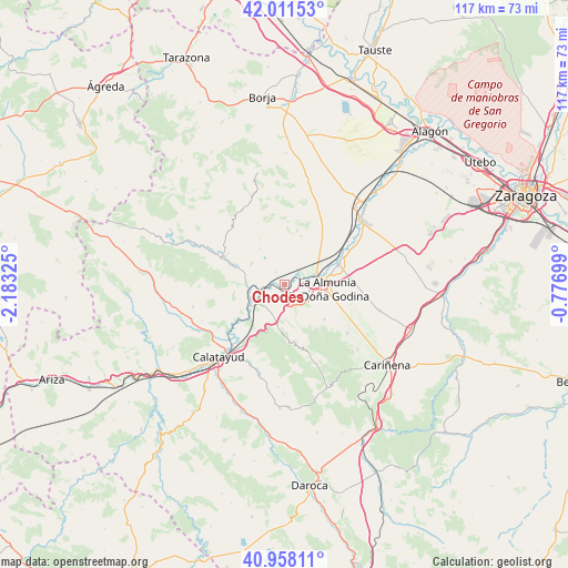
Chodes GPS coordinates[2]
41° 29' 13.056" North, 1° 28' 48.432" West
| Map corner | latitude | longitude |
|---|---|---|
| Upper-left | 42.01153°, | -2.18325° |
| Center: | 41.48696°, | -1.48012° |
| Lower-right: | 40.95811°, | -0.77699° |
| Map W x H: | 117.1×117.1 km | = 72.8×72.8mi |
| max Lat: | 43.74134° ⇑39.4% North |
| Chodes: | 41.48696° |
| min Lat: | ⇓60.6% South 27.64134° |
| min Long | Chodes | max Long |
| -18.00367° | -1.48012° | 4.2899° |
| W 73.1%⇐ | ⇒26.9% E |
Elevation
Elevation of Chodes is 415 m = 1362 ft, and this is 183 m = 600 ft below average elevation for this country.
| Max E: |
1682 m = 5518 ft | 68.1% |
| Avg. | 598 m = 1962 ft | |
| Chodes | 415 m = 1362 ft | |
Min E: |
0 m = 0 ft | 31.9% |
See also: Spain elevation on elevation.city.
Geographical zone
Chodes is located in North temperate zone (between Tropic of Cancer and the Arctic Circle). Distance of this Northern Tropic circle is 2007 km =1247.1 mi to South.| Distance of | km | miles | from Chodes |
|---|---|---|---|
| North Pole | 5394.1 | 3351.7 | to North |
| Arctic Circle | 2788.3 | 1732.6 | to North |
| Tropic Cancer | 2007 | 1247.1 | to South |
| Equator | 4612.9 | 2866.3 | to South |


Nearby cities:
15 places around Chodes: (largest is in red/bold)
• Alpartir
11 km =6.8 mi,  130°
130°
• Arándiga
3 km =1.9 mi,  324°
324°
• Brea de Aragón
11 km =6.8 mi,  291°
291°
• Calatorao
11.8 km =7.3 mi,  70°
70°
• El Frasno
8.2 km =5.1 mi,  189°
189°
• Illueca
13.5 km =8.4 mi, 294°
• La Almunia de Doña Godina
8.9 km =5.5 mi,  97°
97°
• Mesones de Isuela
8.6 km =5.3 mi,  325°
325°
• Morata de Jalón
1.5 km =0.9 mi,  167°
167°
• Morés
7.2 km =4.5 mi,  257°
257°
• Nigüella
6.6 km =4.1 mi, 325°
• Paracuellos de la Ribera
9.9 km =6.2 mi,  223°
223°
• Ricla
6.6 km =4.1 mi, 71°
• Santa Cruz de Grío
13.6 km =8.5 mi,  162°
162°
• Sestrica
9.6 km =6 mi,  269°
269°
Sources, notices
• [Note1] Compared only with cities in Spain existing in our database
• [Src1] Map data: © OpenStreetMap contributors (CC-BY-SA)
• [Src2] Other city data from geonames.org with taken over terms of usage.
• [Src3] Geographical zone / Annual Mean Temperature by Robert A. Rohde @ Wikipedia
