Arándiga geodata
Arándiga (Aragon) is a seat of a third-order administrative division; located in Spain in Europe/Madrid (GMT+2) time zone. With population of 481 people, there are 3933 cities with bigger population in this country. Compared to other cities in Spain, 61% of cities are located further ↓South; 72.9% of cities are located further ←West and 66.3% of cities have higher elevation than Arándiga. Note1


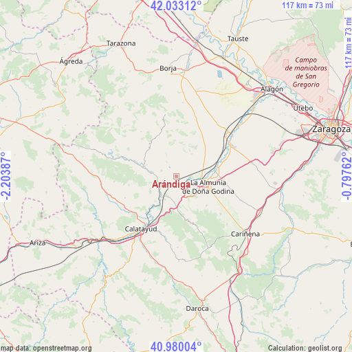
Arándiga GPS coordinates[2]
41° 30' 31.392" North, 1° 30' 2.664" West
| Map corner | latitude | longitude |
|---|---|---|
| Upper-left | 42.03312°, | -2.20387° |
| Center: | 41.50872°, | -1.50074° |
| Lower-right: | 40.98004°, | -0.79762° |
| Map W x H: | 117.1×117.1 km | = 72.8×72.8mi |
| max Lat: | 43.74134° ⇑39% North |
| Arándiga: | 41.50872° |
| min Lat: | ⇓61% South 27.64134° |
| min Long | Arándiga | max Long |
| -18.00367° | -1.50074° | 4.2899° |
| W 72.9%⇐ | ⇒27.1% E |
Elevation
Elevation of Arándiga is 443 m = 1453 ft, and this is 155 m = 509 ft below average elevation for this country.
| Max E: |
1682 m = 5518 ft | 66.3% |
| Avg. | 598 m = 1962 ft | |
| Arándiga | 443 m = 1453 ft | |
Min E: |
0 m = 0 ft | 33.7% |
See also: Spain elevation on elevation.city.
Geographical zone
Arándiga is located in North temperate zone (between Tropic of Cancer and the Arctic Circle). Distance of this Northern Tropic circle is 2009.4 km =1248.6 mi to South.| Distance of | km | miles | from Arándiga |
|---|---|---|---|
| North Pole | 5391.7 | 3350.2 | to North |
| Arctic Circle | 2785.8 | 1731 | to North |
| Tropic Cancer | 2009.4 | 1248.6 | to South |
| Equator | 4615.3 | 2867.8 | to South |


Nearby cities:
15 places around Arándiga: (largest is in red/bold)
• Alpartir
13.9 km =8.6 mi,  133°
133°
• Brea de Aragón
8.6 km =5.3 mi,  281°
281°
• Calatorao
12.9 km =8 mi,  83°
83°
• Chodes
3 km =1.9 mi,  144°
144°
• El Frasno
10.5 km =6.5 mi,  177°
177°
• Gotor
13 km =8.1 mi,  288°
288°
• Illueca
11 km =6.8 mi, 287°
• La Almunia de Doña Godina
11.1 km =6.9 mi,  108°
108°
• Mesones de Isuela
5.7 km =3.5 mi,  326°
326°
• Morata de Jalón
4.4 km =2.7 mi,  152°
152°
• Morés
6.6 km =4.1 mi,  233°
233°
• Nigüella
3.6 km =2.2 mi, 327°
• Paracuellos de la Ribera
10.9 km =6.8 mi,  208°
208°
• Ricla
8 km =5 mi,  92°
92°
• Sestrica
8.2 km =5.1 mi,  252°
252°
Sources, notices
• [Note1] Compared only with cities in Spain existing in our database
• [Src1] Map data: © OpenStreetMap contributors (CC-BY-SA)
• [Src2] Other city data from geonames.org with taken over terms of usage.
• [Src3] Geographical zone / Annual Mean Temperature by Robert A. Rohde @ Wikipedia
