Ricla geodata
Ricla (Aragon) is a seat of a third-order administrative division; located in Spain in Europe/Madrid (GMT+2) time zone. With population of 2,623 people, there are 1849 cities with bigger population in this country. Compared to other cities in Spain, 61% of cities are located further ↓South; 73.8% of cities are located further ←West and 69.5% of cities have higher elevation than Ricla. Note1


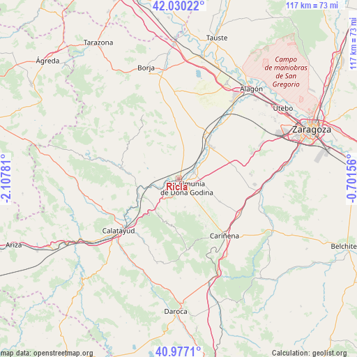
Ricla GPS coordinates[2]
41° 30' 20.88" North, 1° 24' 16.848" West
| Map corner | latitude | longitude |
|---|---|---|
| Upper-left | 42.03022°, | -2.10781° |
| Center: | 41.5058°, | -1.40468° |
| Lower-right: | 40.9771°, | -0.70156° |
| Map W x H: | 117.1×117.1 km | = 72.8×72.8mi |
| max Lat: | 43.74134° ⇑39% North |
| Ricla: | 41.5058° |
| min Lat: | ⇓61% South 27.64134° |
| min Long | Ricla | max Long |
| -18.00367° | -1.40468° | 4.2899° |
| W 73.8%⇐ | ⇒26.2% E |
Elevation
Elevation of Ricla is 392 m = 1286 ft, and this is 206 m = 676 ft below average elevation for this country.
| Max E: |
1682 m = 5518 ft | 69.5% |
| Avg. | 598 m = 1962 ft | |
| Ricla | 392 m = 1286 ft | |
Min E: |
0 m = 0 ft | 30.5% |
See also: Spain elevation on elevation.city.
Geographical zone
Ricla is located in North temperate zone (between Tropic of Cancer and the Arctic Circle). Distance of this Northern Tropic circle is 2009.1 km =1248.4 mi to South.| Distance of | km | miles | from Ricla |
|---|---|---|---|
| North Pole | 5392 | 3350.4 | to North |
| Arctic Circle | 2786.2 | 1731.3 | to North |
| Tropic Cancer | 2009.1 | 1248.4 | to South |
| Equator | 4615 | 2867.6 | to South |


Nearby cities:
15 places around Ricla: (largest is in red/bold)
• Almonacid de la Sierra
13.8 km =8.6 mi,  150°
150°
• Alpartir
9.5 km =5.9 mi,  167°
167°
• Arándiga
8 km =5 mi,  272°
272°
• Calatorao
5.1 km =3.2 mi,  69°
69°
• Chodes
6.6 km =4.1 mi,  251°
251°
• El Frasno
12.7 km =7.9 mi,  216°
216°
• La Almunia de Doña Godina
4.1 km =2.5 mi,  142°
142°
• Lucena de Jalón
9.3 km =5.8 mi,  55°
55°
• Mesones de Isuela
12.2 km =7.6 mi,  294°
294°
• Morata de Jalón
7 km =4.3 mi,  238°
238°
• Morés
13.8 km =8.6 mi, 254°
• Nigüella
10.5 km =6.5 mi, 288°
• Salillas de Jalón
9.7 km =6 mi,  44°
44°
• Santa Cruz de Grío
15.2 km =9.4 mi,  188°
188°
• Épila
14.8 km =9.2 mi, 44°
Sources, notices
• [Note1] Compared only with cities in Spain existing in our database
• [Src1] Map data: © OpenStreetMap contributors (CC-BY-SA)
• [Src2] Other city data from geonames.org with taken over terms of usage.
• [Src3] Geographical zone / Annual Mean Temperature by Robert A. Rohde @ Wikipedia
