Torralba de Ribota geodata
Torralba de Ribota (Aragon) is a seat of a third-order administrative division; located in Spain in Europe/Madrid (GMT+2) time zone. With population of 184 people, there are 5155 cities with bigger population in this country. Compared to other cities in Spain, 58.4% of cities are located further ↓South; 70.9% of cities are located further ←West and 50.4% of cities have higher elevation than Torralba de Ribota. Note1
Administrative division(s):
- Level 1: Aragon
- Level 2: Provincia de Zaragoza
- Level 3: Torralba de Ribota


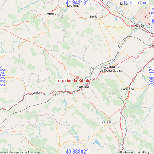
Torralba de Ribota GPS coordinates[2]
41° 25' 4.908" North, 1° 41' 3.444" West
| Map corner | latitude | longitude |
|---|---|---|
| Upper-left | 41.94316°, | -2.38742° |
| Center: | 41.41803°, | -1.68429° |
| Lower-right: | 40.88862°, | -0.98117° |
| Map W x H: | 117.3×117.3 km | = 72.9×72.9mi |
| max Lat: | 43.74134° ⇑41.6% North |
| Torralba de Ribota: | 41.41803° |
| min Lat: | ⇓58.4% South 27.64134° |
| min Long | Torralba de Rib | max Long |
| -18.00367° | -1.68429° | 4.2899° |
| W 70.9%⇐ | ⇒29.1% E |
Elevation
Elevation of Torralba de Ribota is 653 m = 2142 ft, and this is 55 m = 180 ft above average elevation for this country.
| Max E: |
1682 m = 5518 ft | 50.4% |
| Torralba de Ribota | 653 m 2142 ft | |
| Avg. | 598 m = 1962 ft | |
Min E: |
0 m = 0 ft | 49.6% |
See also: Spain elevation on elevation.city.
Geographical zone
Torralba de Ribota is located in North temperate zone (between Tropic of Cancer and the Arctic Circle). Distance of this Northern Tropic circle is 1999.3 km =1242.3 mi to South.| Distance of | km | miles | from Torralba de Ribota |
|---|---|---|---|
| North Pole | 5401.8 | 3356.5 | to North |
| Arctic Circle | 2795.9 | 1737.3 | to North |
| Tropic Cancer | 1999.3 | 1242.3 | to South |
| Equator | 4605.3 | 2861.6 | to South |


Nearby cities:
15 places around Torralba de Ribota: (largest is in red/bold)
• Aniñon
3.4 km =2.1 mi,  330°
330°
• Ateca
13.3 km =8.3 mi,  223°
223°
• Brea de Aragón
13.6 km =8.5 mi,  30°
30°
• Calatayud
7.9 km =4.9 mi,  154°
154°
• Cervera de la Cañada
4.6 km =2.9 mi,  291°
291°
• Illueca
14.2 km =8.8 mi,  19°
19°
• Moros
12.2 km =7.6 mi,  259°
259°
• Morés
11.7 km =7.3 mi,  58°
58°
• Paracuellos de Jiloca
12.2 km =7.6 mi,  162°
162°
• Paracuellos de la Ribera
10.2 km =6.3 mi,  87°
87°
• Sestrica
10.6 km =6.6 mi,  44°
44°
• Terrer
10.3 km =6.4 mi,  193°
193°
• Valtorres
14.1 km =8.8 mi,  199°
199°
• Villalengua
13.2 km =8.2 mi,  278°
278°
• Villarroya de la Sierra
9.7 km =6 mi,  301°
301°
Sources, notices
• [Note1] Compared only with cities in Spain existing in our database
• [Src1] Map data: © OpenStreetMap contributors (CC-BY-SA)
• [Src2] Other city data from geonames.org with taken over terms of usage.
• [Src3] Geographical zone / Annual Mean Temperature by Robert A. Rohde @ Wikipedia
