Paracuellos de la Ribera geodata
Paracuellos de la Ribera (Aragon) is a seat of a third-order administrative division; located in Spain in Europe/Madrid (GMT+2) time zone. With population of 223 people, there are 4894 cities with bigger population in this country. Compared to other cities in Spain, 58.6% of cities are located further ↓South; 72.3% of cities are located further ←West and 62% of cities have higher elevation than Paracuellos de la Ribera. Note1
Administrative division(s):
- Level 1: Aragon
- Level 2: Provincia de Zaragoza
- Level 3: Paracuellos de la Ribera
Current local time in Paracuellos de la Ribera:
01:19 AM, FridayDifference from your time zone: hours


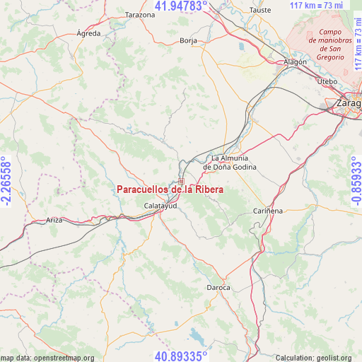
Paracuellos de la Ribera GPS coordinates[2]
41° 25' 21.828" North, 1° 33' 44.82" West
| Map corner | latitude | longitude |
|---|---|---|
| Upper-left | 41.94783°, | -2.26558° |
| Center: | 41.42273°, | -1.56245° |
| Lower-right: | 40.89335°, | -0.85933° |
| Map W x H: | 117.2×117.2 km | = 72.8×72.8mi |
| max Lat: | 43.74134° ⇑41.4% North |
| Paracuellos de la Ribera: | 41.42273° |
| min Lat: | ⇓58.6% South 27.64134° |
| min Long | Paracuellos de | max Long |
| -18.00367° | -1.56245° | 4.2899° |
| W 72.3%⇐ | ⇒27.7% E |
Elevation
Elevation of Paracuellos de la Ribera is 499 m = 1637 ft, and this is 99 m = 325 ft below average elevation for this country.
| Max E: |
1682 m = 5518 ft | 62% |
| Avg. | 598 m = 1962 ft | |
| Paracuellos de la Ribera | 499 m = 1637 ft | |
Min E: |
0 m = 0 ft | 38% |
See also: Spain elevation on elevation.city.
Geographical zone
Paracuellos de la Ribera is located in North temperate zone (between Tropic of Cancer and the Arctic Circle). Distance of this Northern Tropic circle is 1999.9 km =1242.7 mi to South.| Distance of | km | miles | from Paracuellos de la Ribera |
|---|---|---|---|
| North Pole | 5401.3 | 3356.2 | to North |
| Arctic Circle | 2795.4 | 1737 | to North |
| Tropic Cancer | 1999.9 | 1242.7 | to South |
| Equator | 4605.8 | 2861.9 | to South |


Nearby cities:
15 places around Paracuellos de la Ribera: (largest is in red/bold)
• Aniñon
12.1 km =7.5 mi,  281°
281°
• Arándiga
10.9 km =6.8 mi,  28°
28°
• Brea de Aragón
11.7 km =7.3 mi,  343°
343°
• Calatayud
10.2 km =6.3 mi,  221°
221°
• Chodes
9.9 km =6.2 mi,  43°
43°
• El Frasno
5.6 km =3.5 mi,  99°
99°
• Morata de Jalón
9.1 km =5.7 mi,  51°
51°
• Morés
5.6 km =3.5 mi,  357°
357°
• Nigüella
13 km =8.1 mi,  14°
14°
• Paracuellos de Jiloca
13.7 km =8.5 mi,  208°
208°
• Santa Cruz de Grío
12.5 km =7.8 mi,  117°
117°
• Sediles
8.9 km =5.5 mi,  163°
163°
• Sestrica
7.5 km =4.7 mi, 338°
• Torralba de Ribota
10.2 km =6.3 mi,  267°
267°
• Villalba de Perejil
10.7 km =6.6 mi,  173°
173°
Sources, notices
• [Note1] Compared only with cities in Spain existing in our database
• [Src1] Map data: © OpenStreetMap contributors (CC-BY-SA)
• [Src2] Other city data from geonames.org with taken over terms of usage.
• [Src3] Geographical zone / Annual Mean Temperature by Robert A. Rohde @ Wikipedia
