Encío geodata
Encío (Castille and León) is a seat of a third-order administrative division; located in Spain in Europe/Madrid (GMT+2) time zone. With population of 46 people, there are 6506 cities with bigger population in this country. Compared to other cities in Spain, 91.1% of cities are located further ↓South; 53% of cities are located further ←West and 52.4% of cities have higher elevation than Encío. Note1


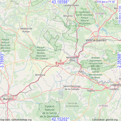
Encío GPS coordinates[2]
42° 40' 16.14" North, 3° 5' 12.48" West
| Map corner | latitude | longitude |
|---|---|---|
| Upper-left | 43.18598°, | -3.78993° |
| Center: | 42.67115°, | -3.0868° |
| Lower-right: | 42.15202°, | -2.38368° |
| Map W x H: | 115×115 km | = 71.5×71.5mi |
| max Lat: | 43.74134° ⇑8.9% North |
| Encío: | 42.67115° |
| min Lat: | ⇓91.1% South 27.64134° |
| min Long | Encío | max Long |
| -18.00367° | -3.0868° | 4.2899° |
| W 53%⇐ | ⇒47% E |
Elevation
Elevation of Encío is 632 m = 2073 ft, and this is 34 m = 112 ft above average elevation for this country.
| Max E: |
1682 m = 5518 ft | 52.4% |
| Encío | 632 m 2073 ft | |
| Avg. | 598 m = 1962 ft | |
Min E: |
0 m = 0 ft | 47.6% |
See also: Spain elevation on elevation.city.
Geographical zone
Encío is located in North temperate zone (between Tropic of Cancer and the Arctic Circle). Distance of this Northern Tropic circle is 2138.7 km =1328.9 mi to South.| Distance of | km | miles | from Encío |
|---|---|---|---|
| North Pole | 5262.5 | 3270 | to North |
| Arctic Circle | 2656.6 | 1650.7 | to North |
| Tropic Cancer | 2138.7 | 1328.9 | to South |
| Equator | 4744.6 | 2948.2 | to South |


Nearby cities:
15 places around Encío: (largest is in red/bold)
• Altable
7.6 km =4.7 mi,  174°
174°
• Ameyugo
2.6 km =1.6 mi,  129°
129°
• Bugedo
6.1 km =3.8 mi,  113°
113°
• Cascajares de Bureba
12.4 km =7.7 mi,  273°
273°
• Cellorigo
8.6 km =5.3 mi,  124°
124°
• Cubo de Bureba
10.4 km =6.5 mi,  250°
250°
• Foncea
7.3 km =4.5 mi,  147°
147°
• Fonzaleche
11.7 km =7.3 mi, 148°
• Galbárruli
11.7 km =7.3 mi, 118°
• Miranda de Ebro
11.6 km =7.2 mi,  81°
81°
• Miraveche
9.2 km =5.7 mi, 271°
• Pancorbo
4.6 km =2.9 mi,  206°
206°
• Santa Gadea del Cid
5.4 km =3.4 mi,  24°
24°
• Valluércanes
11.4 km =7.1 mi,  194°
194°
• Villanueva de Teba
6.7 km =4.2 mi, 248°
Sources, notices
• [Note1] Compared only with cities in Spain existing in our database
• [Src1] Map data: © OpenStreetMap contributors (CC-BY-SA)
• [Src2] Other city data from geonames.org with taken over terms of usage.
• [Src3] Geographical zone / Annual Mean Temperature by Robert A. Rohde @ Wikipedia
