Abrera geodata
Abrera (Catalonia) is a populated place; located in Spain in Europe/Madrid (GMT+2) time zone. With population of 11,521 people, there are 768 cities with bigger population in this country. Compared to other cities in Spain, 61.2% of cities are located further ↓South; 93.1% of cities are located further ←West and 86.9% of cities have higher elevation than Abrera. Note1


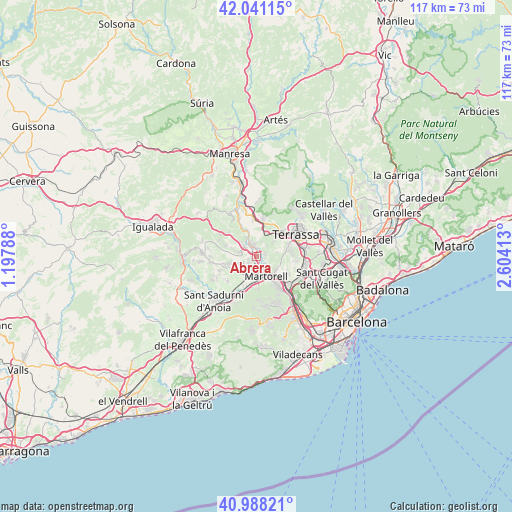
Abrera GPS coordinates[2]
41° 31' 0.552" North, 1° 54' 3.6" East
| Map corner | latitude | longitude |
|---|---|---|
| Upper-left | 42.04115°, | 1.19788° |
| Center: | 41.51682°, | 1.901° |
| Lower-right: | 40.98821°, | 2.60413° |
| Map W x H: | 117.1×117.1 km | = 72.8×72.8mi |
| max Lat: | 43.74134° ⇑38.8% North |
| Abrera: | 41.51682° |
| min Lat: | ⇓61.2% South 27.64134° |
| min Long | Abrera | max Long |
| -18.00367° | 1.901° | 4.2899° |
| W 93.1%⇐ | ⇒6.9% E |
Elevation
Elevation of Abrera is 111 m = 364 ft, and this is 487 m = 1598 ft below average elevation for this country.
| Max E: |
1682 m = 5518 ft | 86.9% |
| Avg. | 598 m = 1962 ft | |
| Abrera | 111 m = 364 ft | |
Min E: |
0 m = 0 ft | 13.1% |
See also: Spain elevation on elevation.city.
Geographical zone
Abrera is located in North temperate zone (between Tropic of Cancer and the Arctic Circle). Distance of this Northern Tropic circle is 2010.3 km =1249.1 mi to South.| Distance of | km | miles | from Abrera |
|---|---|---|---|
| North Pole | 5390.8 | 3349.7 | to North |
| Arctic Circle | 2784.9 | 1730.5 | to North |
| Tropic Cancer | 2010.3 | 1249.1 | to South |
| Equator | 4616.2 | 2868.4 | to South |


Nearby cities:
15 places around Abrera: (largest is in red/bold)
• Castellbisbal
8.2 km =5.1 mi,  124°
124°
• Castellví de Rosanes
7.4 km =4.6 mi,  180°
180°
• Collbató
8.5 km =5.3 mi,  313°
313°
• Corbera de Llobregat
11.2 km =7 mi,  172°
172°
• Esparreguera
3.5 km =2.2 mi, 312°
• Gelida
9.7 km =6 mi,  197°
197°
• Martorell
5.4 km =3.4 mi,  152°
152°
• Masquefa
7.6 km =4.7 mi,  258°
258°
• Olesa de Montserrat
3 km =1.9 mi,  349°
349°
• Rubí
11.3 km =7 mi,  103°
103°
• Sant Andreu de la Barca
9.8 km =6.1 mi,  142°
142°
• Sant Llorenç d'Hortons
7.9 km =4.9 mi,  225°
225°
• Terrassa
11.1 km =6.9 mi,  60°
60°
• Ullastrell
4.7 km =2.9 mi,  76°
76°
• Viladecavalls
5.5 km =3.4 mi,  47°
47°
Sources, notices
• [Note1] Compared only with cities in Spain existing in our database
• [Src1] Map data: © OpenStreetMap contributors (CC-BY-SA)
• [Src2] Other city data from geonames.org with taken over terms of usage.
• [Src3] Geographical zone / Annual Mean Temperature by Robert A. Rohde @ Wikipedia
