Paracuellos de Jiloca geodata
Paracuellos de Jiloca (Aragon) is a seat of a third-order administrative division; located in Spain in Europe/Madrid (GMT+2) time zone. With population of 514 people, there are 3836 cities with bigger population in this country. Compared to other cities in Spain, 55.5% of cities are located further ↓South; 71.5% of cities are located further ←West and 56.9% of cities have higher elevation than Paracuellos de Jiloca. Note1
Administrative division(s):
- Level 1: Aragon
- Level 2: Provincia de Zaragoza
- Level 3: Paracuellos de Jiloca


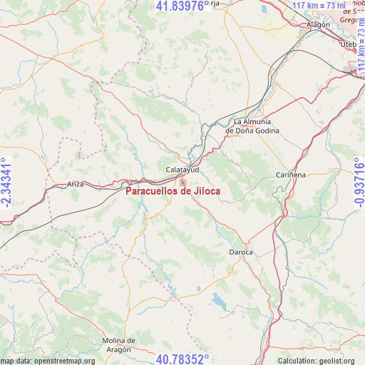
Paracuellos de Jiloca GPS coordinates[2]
41° 18' 49.608" North, 1° 38' 25.044" West
| Map corner | latitude | longitude |
|---|---|---|
| Upper-left | 41.83976°, | -2.34341° |
| Center: | 41.31378°, | -1.64029° |
| Lower-right: | 40.78352°, | -0.93716° |
| Map W x H: | 117.4×117.4 km | = 72.9×72.9mi |
| max Lat: | 43.74134° ⇑44.5% North |
| Paracuellos de Jiloca: | 41.31378° |
| min Lat: | ⇓55.5% South 27.64134° |
| min Long | Paracuellos de | max Long |
| -18.00367° | -1.64029° | 4.2899° |
| W 71.5%⇐ | ⇒28.5% E |
Elevation
Elevation of Paracuellos de Jiloca is 568 m = 1864 ft, and this is 30 m = 98 ft below average elevation for this country.
| Max E: |
1682 m = 5518 ft | 56.9% |
| Avg. | 598 m = 1962 ft | |
| Paracuellos de Jiloca | 568 m = 1864 ft | |
Min E: |
0 m = 0 ft | 43.1% |
See also: Spain elevation on elevation.city.
Geographical zone
Paracuellos de Jiloca is located in North temperate zone (between Tropic of Cancer and the Arctic Circle). Distance of this Northern Tropic circle is 1987.7 km =1235.1 mi to South.| Distance of | km | miles | from Paracuellos de Jiloca |
|---|---|---|---|
| North Pole | 5413.4 | 3363.7 | to North |
| Arctic Circle | 2807.5 | 1744.5 | to North |
| Tropic Cancer | 1987.7 | 1235.1 | to South |
| Equator | 4593.7 | 2854.4 | to South |


Nearby cities:
15 places around Paracuellos de Jiloca: (largest is in red/bold)
• Alarba
12.3 km =7.6 mi,  169°
169°
• Ateca
12.9 km =8 mi,  278°
278°
• Calatayud
4.4 km =2.7 mi,  356°
356°
• Fuentes de Jiloca
12.9 km =8 mi,  137°
137°
• Maluenda
3.5 km =2.2 mi,  145°
145°
• Mara
10.5 km =6.5 mi,  104°
104°
• Morata de Jiloca
8.6 km =5.3 mi, 148°
• Munébrega
8.8 km =5.5 mi,  218°
218°
• Olvés
8.3 km =5.2 mi,  183°
183°
• Sediles
9.7 km =6 mi,  68°
68°
• Terrer
6.3 km =3.9 mi, 284°
• Torralba de Ribota
12.2 km =7.6 mi,  342°
342°
• Valtorres
8.6 km =5.3 mi,  258°
258°
• Velilla de Jiloca
5.3 km =3.3 mi, 144°
• Villalba de Perejil
7.8 km =4.8 mi,  78°
78°
Sources, notices
• [Note1] Compared only with cities in Spain existing in our database
• [Src1] Map data: © OpenStreetMap contributors (CC-BY-SA)
• [Src2] Other city data from geonames.org with taken over terms of usage.
• [Src3] Geographical zone / Annual Mean Temperature by Robert A. Rohde @ Wikipedia
