Olvés geodata
Olvés (Aragon) is a seat of a third-order administrative division; located in Spain in Europe/Madrid (GMT+2) time zone. With population of 130 people, there are 5579 cities with bigger population in this country. Compared to other cities in Spain, 54.2% of cities are located further ↓South; 71.4% of cities are located further ←West and 67.5% of cities have lower elevation than Olvés. Note1


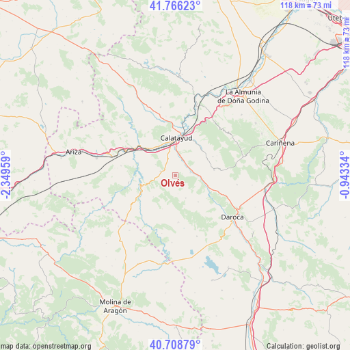
Olvés GPS coordinates[2]
41° 14' 22.74" North, 1° 38' 47.292" West
| Map corner | latitude | longitude |
|---|---|---|
| Upper-left | 41.76623°, | -2.34959° |
| Center: | 41.23965°, | -1.64647° |
| Lower-right: | 40.70879°, | -0.94334° |
| Map W x H: | 117.6×117.6 km | = 73.1×73.1mi |
| max Lat: | 43.74134° ⇑45.8% North |
| Olvés: | 41.23965° |
| min Lat: | ⇓54.2% South 27.64134° |
| min Long | Olvés | max Long |
| -18.00367° | -1.64647° | 4.2899° |
| W 71.4%⇐ | ⇒28.6% E |
Elevation
Elevation of Olvés is 795 m = 2608 ft, and this is 197 m = 646 ft above average elevation for this country.
| Max E: |
1682 m = 5518 ft | 32.5% |
| Olvés | 795 m 2608 ft | |
| Avg. | 598 m = 1962 ft | |
Min E: |
0 m = 0 ft | 67.5% |
See also: Spain elevation on elevation.city.
Geographical zone
Olvés is located in North temperate zone (between Tropic of Cancer and the Arctic Circle). Distance of this Northern Tropic circle is 1979.5 km =1230 mi to South.| Distance of | km | miles | from Olvés |
|---|---|---|---|
| North Pole | 5421.6 | 3368.8 | to North |
| Arctic Circle | 2815.8 | 1749.7 | to North |
| Tropic Cancer | 1979.5 | 1230 | to South |
| Equator | 4585.4 | 2849.2 | to South |


Nearby cities:
15 places around Olvés: (largest is in red/bold)
• Acered
8.4 km =5.2 mi,  155°
155°
• Alarba
4.8 km =3 mi,  144°
144°
• Atea
11.6 km =7.2 mi, 139°
• Castejón de Alarba
6.3 km =3.9 mi,  172°
172°
• Fuentes de Jiloca
9.3 km =5.8 mi,  97°
97°
• Maluenda
5.9 km =3.7 mi,  25°
25°
• Mara
12.1 km =7.5 mi,  62°
62°
• Monterde
10.4 km =6.5 mi,  225°
225°
• Montón
11.6 km =7.2 mi,  108°
108°
• Morata de Jiloca
5.1 km =3.2 mi,  79°
79°
• Munébrega
5.1 km =3.2 mi,  285°
285°
• Paracuellos de Jiloca
8.3 km =5.2 mi,  3°
3°
• Terrer
11.3 km =7 mi,  330°
330°
• Valtorres
10.2 km =6.3 mi,  309°
309°
• Velilla de Jiloca
5.3 km =3.3 mi,  42°
42°
Sources, notices
• [Note1] Compared only with cities in Spain existing in our database
• [Src1] Map data: © OpenStreetMap contributors (CC-BY-SA)
• [Src2] Other city data from geonames.org with taken over terms of usage.
• [Src3] Geographical zone / Annual Mean Temperature by Robert A. Rohde @ Wikipedia
