Las Matas geodata
Las Matas (Madrid) is a populated place; located in Spain in Europe/Madrid (GMT+2) time zone. With population of 14,213 people, there are 646 cities with bigger population in this country. Compared to other cities in Spain, 60.6% of cities are located further ↑North; 58.1% of cities are located further →East and 58.9% of cities have lower elevation than Las Matas. Note1
Administrative division(s):
- Level 1: Madrid
- Level 2: Provincia de Madrid
- Level 3: Las Rozas de Madrid


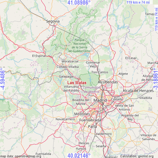
Las Matas GPS coordinates[2]
40° 33' 28.044" North, 3° 53' 30.228" West
| Map corner | latitude | longitude |
|---|---|---|
| Upper-left | 41.08986°, | -4.59486° |
| Center: | 40.55779°, | -3.89173° |
| Lower-right: | 40.02146°, | -3.18861° |
| Map W x H: | 118.8×118.8 km | = 73.8×73.8mi |
| max Lat: | 43.74134° ⇑60.6% North |
| Las Matas: | 40.55779° |
| min Lat: | ⇓39.4% South 27.64134° |
| min Long | Las Matas | max Long |
| -18.00367° | -3.89173° | 4.2899° |
| W 41.9%⇐ | ⇒58.1% E |
Elevation
Elevation of Las Matas is 736 m = 2415 ft, and this is 138 m = 453 ft above average elevation for this country.
| Max E: |
1682 m = 5518 ft | 41.1% |
| Las Matas | 736 m 2415 ft | |
| Avg. | 598 m = 1962 ft | |
Min E: |
0 m = 0 ft | 58.9% |
See also: Spain elevation on elevation.city.
Geographical zone
Las Matas is located in North temperate zone (between Tropic of Cancer and the Arctic Circle). Distance of this Northern Tropic circle is 1903.7 km =1182.9 mi to South.| Distance of | km | miles | from Las Matas |
|---|---|---|---|
| North Pole | 5497.5 | 3416 | to North |
| Arctic Circle | 2891.6 | 1796.8 | to North |
| Tropic Cancer | 1903.7 | 1182.9 | to South |
| Equator | 4509.6 | 2802.1 | to South |


Nearby cities:
15 places around Las Matas: (largest is in red/bold)
• Collado-Villalba
12.8 km =8 mi,  311°
311°
• Colmenar Viejo
15.4 km =9.6 mi,  42°
42°
• Colmenarejo
10.6 km =6.6 mi,  271°
271°
• El Pardo
11.2 km =7 mi,  115°
115°
• Fuencarral-El Pardo
15.1 km =9.4 mi, 115°
• Galapagar
9.8 km =6.1 mi,  283°
283°
• Hoyo de Manzanares
7.3 km =4.5 mi,  349°
349°
• Las Rozas de Madrid
7.4 km =4.6 mi,  168°
168°
• Majadahonda
9.5 km =5.9 mi, 169°
• Moralzarzal
15 km =9.3 mi,  333°
333°
• Navalquejigo
14.4 km =8.9 mi,  292°
292°
• Pozuelo de Alarcón
15.4 km =9.6 mi,  154°
154°
• Torrelodones
3.6 km =2.2 mi, 305°
• Villanueva de la Cañada
15.6 km =9.7 mi,  217°
217°
• Villanueva del Pardillo
9.7 km =6 mi, 219°
Sources, notices
• [Note1] Compared only with cities in Spain existing in our database
• [Src1] Map data: © OpenStreetMap contributors (CC-BY-SA)
• [Src2] Other city data from geonames.org with taken over terms of usage.
• [Src3] Geographical zone / Annual Mean Temperature by Robert A. Rohde @ Wikipedia
