Alcorcón geodata
Alcorcón (Madrid) is a seat of a third-order administrative division; located in Spain in Europe/Madrid (GMT+2) time zone. With population of 167,967 people, there are 47 cities with bigger population in this country. Compared to other cities in Spain, 65% of cities are located further ↑North; 57.2% of cities are located further →East and 57.9% of cities have lower elevation than Alcorcón. Note1


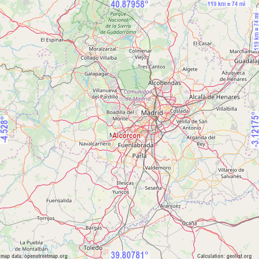
Alcorcón GPS coordinates[2]
40° 20' 44.952" North, 3° 49' 29.532" West
| Map corner | latitude | longitude |
|---|---|---|
| Upper-left | 40.87958°, | -4.528° |
| Center: | 40.34582°, | -3.82487° |
| Lower-right: | 39.80781°, | -3.12175° |
| Map W x H: | 119.2×119.2 km | = 74.1×74.1mi |
| max Lat: | 43.74134° ⇑65% North |
| Alcorcón: | 40.34582° |
| min Lat: | ⇓35% South 27.64134° |
| min Long | Alcorcón | max Long |
| -18.00367° | -3.82487° | 4.2899° |
| W 42.8%⇐ | ⇒57.2% E |
Elevation
Elevation of Alcorcón is 729 m = 2392 ft, and this is 131 m = 430 ft above average elevation for this country.
| Max E: |
1682 m = 5518 ft | 42.1% |
| Alcorcón | 729 m 2392 ft | |
| Avg. | 598 m = 1962 ft | |
Min E: |
0 m = 0 ft | 57.9% |
See also: Alcorcón elevation on elevation.city.
Geographical zone
Alcorcón is located in North temperate zone (between Tropic of Cancer and the Arctic Circle). Distance of this Northern Tropic circle is 1880.1 km =1168.2 mi to South.| Distance of | km | miles | from Alcorcón |
|---|---|---|---|
| North Pole | 5521 | 3430.6 | to North |
| Arctic Circle | 2915.1 | 1811.4 | to North |
| Tropic Cancer | 1880.1 | 1168.2 | to South |
| Equator | 4486 | 2787.5 | to South |


Nearby cities:
15 places around Alcorcón: (largest is in red/bold)
• Arganzuela
12.5 km =7.8 mi,  60°
60°
• Arroyomolinos
11.7 km =7.3 mi,  223°
223°
• Boadilla del Monte
8 km =5 mi,  325°
325°
• Carabanchel
9.9 km =6.2 mi, 59°
• Fuenlabrada
7.3 km =4.5 mi,  159°
159°
• Getafe
9 km =5.6 mi,  119°
119°
• Humanes de Madrid
10.6 km =6.6 mi,  182°
182°
• Latina
8.2 km =5.1 mi,  54°
54°
• Leganés
5.6 km =3.5 mi,  111°
111°
• Moraleja de Enmedio
9.9 km =6.2 mi,  197°
197°
• Móstoles
4.3 km =2.7 mi,  232°
232°
• Pozuelo de Alarcón
9.7 km =6 mi,  5°
5°
• Usera
11.6 km =7.2 mi,  65°
65°
• Villaverde
10.6 km =6.6 mi,  87°
87°
• Villaviciosa de Odón
6.9 km =4.3 mi,  281°
281°
Sources, notices
• [Note1] Compared only with cities in Spain existing in our database
• [Src1] Map data: © OpenStreetMap contributors (CC-BY-SA)
• [Src2] Other city data from geonames.org with taken over terms of usage.
• [Src3] Geographical zone / Annual Mean Temperature by Robert A. Rohde @ Wikipedia
