Lastras de Cuéllar geodata
Lastras de Cuéllar (Castille and León) is a seat of a third-order administrative division; located in Spain in Europe/Madrid (GMT+2) time zone. With population of 469 people, there are 3968 cities with bigger population in this country. Compared to other cities in Spain, 55.3% of cities are located further ↓South; 61.3% of cities are located further →East and 80.8% of cities have lower elevation than Lastras de Cuéllar. Note1
Administrative division(s):
- Level 1: Castille and León
- Level 2: Provincia de Segovia
- Level 3: Lastras de Cuéllar


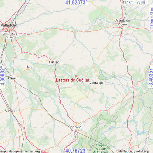
Lastras de Cuéllar GPS coordinates[2]
41° 17' 51.432" North, 4° 6' 24.12" West
| Map corner | latitude | longitude |
|---|---|---|
| Upper-left | 41.82373°, | -4.80982° |
| Center: | 41.29762°, | -4.1067° |
| Lower-right: | 40.76723°, | -3.40357° |
| Map W x H: | 117.5×117.5 km | = 73×73mi |
| max Lat: | 43.74134° ⇑44.7% North |
| Lastras de Cuéllar: | 41.29762° |
| min Lat: | ⇓55.3% South 27.64134° |
| min Long | Lastras de Cué | max Long |
| -18.00367° | -4.1067° | 4.2899° |
| W 38.7%⇐ | ⇒61.3% E |
Elevation
Elevation of Lastras de Cuéllar is 905 m = 2969 ft, and this is 307 m = 1007 ft above average elevation for this country.
| Max E: |
1682 m = 5518 ft | 19.2% |
| Lastras de Cuéllar | 905 m 2969 ft | |
| Avg. | 598 m = 1962 ft | |
Min E: |
0 m = 0 ft | 80.8% |
See also: Spain elevation on elevation.city.
Geographical zone
Lastras de Cuéllar is located in North temperate zone (between Tropic of Cancer and the Arctic Circle). Distance of this Northern Tropic circle is 1985.9 km =1234 mi to South.| Distance of | km | miles | from Lastras de Cuéllar |
|---|---|---|---|
| North Pole | 5415.2 | 3364.8 | to North |
| Arctic Circle | 2809.3 | 1745.6 | to North |
| Tropic Cancer | 1985.9 | 1234 | to South |
| Equator | 4591.9 | 2853.3 | to South |


Nearby cities:
15 places around Lastras de Cuéllar: (largest is in red/bold)
• Adrados
7.9 km =4.9 mi,  356°
356°
• Aguilafuente
7.9 km =4.9 mi,  183°
183°
• Aldea Real
13.4 km =8.3 mi,  201°
201°
• Cozuelos de Fuentidueña
10.4 km =6.5 mi,  5°
5°
• Frumales
11.6 km =7.2 mi,  325°
325°
• Fuente el Olmo de Fuentidueña
12.7 km =7.9 mi,  44°
44°
• Fuentepelayo
10.2 km =6.3 mi,  214°
214°
• Fuentepiñel
12.5 km =7.8 mi,  25°
25°
• Fuentesaúco de Fuentidueña
14.6 km =9.1 mi, 14°
• Hontalbilla
5.5 km =3.4 mi,  346°
346°
• Olombrada
13.8 km =8.6 mi,  340°
340°
• Perosillo
11 km =6.8 mi, 344°
• Sauquillo de Cabezas
11.9 km =7.4 mi,  164°
164°
• Torrecilla del Pinar
10.2 km =6.3 mi, 34°
• Zarzuela del Pinar
7.7 km =4.8 mi,  237°
237°
Sources, notices
• [Note1] Compared only with cities in Spain existing in our database
• [Src1] Map data: © OpenStreetMap contributors (CC-BY-SA)
• [Src2] Other city data from geonames.org with taken over terms of usage.
• [Src3] Geographical zone / Annual Mean Temperature by Robert A. Rohde @ Wikipedia
