Frumales geodata
Frumales (Castille and León) is a seat of a third-order administrative division; located in Spain in Europe/Madrid (GMT+2) time zone. With population of 172 people, there are 5251 cities with bigger population in this country. Compared to other cities in Spain, 57.2% of cities are located further ↓South; 62.4% of cities are located further →East and 70.9% of cities have lower elevation than Frumales. Note1
Administrative division(s):
- Level 1: Castille and León
- Level 2: Provincia de Segovia
- Level 3: Frumales


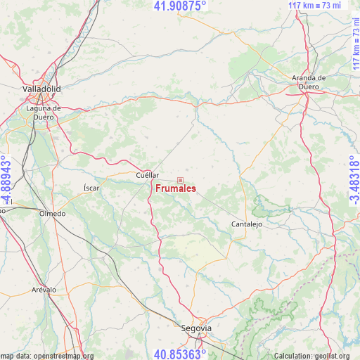
Frumales GPS coordinates[2]
41° 22' 59.988" North, 4° 11' 10.716" West
| Map corner | latitude | longitude |
|---|---|---|
| Upper-left | 41.90875°, | -4.88943° |
| Center: | 41.38333°, | -4.18631° |
| Lower-right: | 40.85363°, | -3.48318° |
| Map W x H: | 117.3×117.3 km | = 72.9×72.9mi |
| max Lat: | 43.74134° ⇑42.8% North |
| Frumales: | 41.38333° |
| min Lat: | ⇓57.2% South 27.64134° |
| min Long | Frumales | max Long |
| -18.00367° | -4.18631° | 4.2899° |
| W 37.6%⇐ | ⇒62.4% E |
Elevation
Elevation of Frumales is 820 m = 2690 ft, and this is 222 m = 728 ft above average elevation for this country.
| Max E: |
1682 m = 5518 ft | 29.1% |
| Frumales | 820 m 2690 ft | |
| Avg. | 598 m = 1962 ft | |
Min E: |
0 m = 0 ft | 70.9% |
See also: Spain elevation on elevation.city.
Geographical zone
Frumales is located in North temperate zone (between Tropic of Cancer and the Arctic Circle). Distance of this Northern Tropic circle is 1995.5 km =1239.9 mi to South.| Distance of | km | miles | from Frumales |
|---|---|---|---|
| North Pole | 5405.7 | 3358.9 | to North |
| Arctic Circle | 2799.8 | 1739.7 | to North |
| Tropic Cancer | 1995.5 | 1239.9 | to South |
| Equator | 4601.4 | 2859.2 | to South |


Nearby cities:
15 places around Frumales: (largest is in red/bold)
• Adrados
6.4 km =4 mi,  105°
105°
• Bahabón
13.4 km =8.3 mi,  324°
324°
• Campaspero
12.1 km =7.5 mi,  356°
356°
• Cozuelos de Fuentidueña
7.6 km =4.7 mi,  83°
83°
• Cuéllar
10.9 km =6.8 mi,  280°
280°
• Fuentepiñel
12.1 km =7.5 mi, 81°
• Fuentesaúco de Fuentidueña
11.3 km =7 mi,  66°
66°
• Hontalbilla
6.9 km =4.3 mi,  127°
127°
• Lastras de Cuéllar
11.6 km =7.2 mi,  145°
145°
• Membibre de la Hoz
10.6 km =6.6 mi,  45°
45°
• Olombrada
4.1 km =2.5 mi,  31°
31°
• Perosillo
3.9 km =2.4 mi, 74°
• Sanchonuño
12 km =7.5 mi,  236°
236°
• Torrecilla del Pinar
12.4 km =7.7 mi,  95°
95°
• Zarzuela del Pinar
13.7 km =8.5 mi,  179°
179°
Sources, notices
• [Note1] Compared only with cities in Spain existing in our database
• [Src1] Map data: © OpenStreetMap contributors (CC-BY-SA)
• [Src2] Other city data from geonames.org with taken over terms of usage.
• [Src3] Geographical zone / Annual Mean Temperature by Robert A. Rohde @ Wikipedia
