Colmenar Viejo geodata
Colmenar Viejo (Madrid) is a seat of a third-order administrative division; located in Spain in Europe/Madrid (GMT+2) time zone. With population of 43,700 people, there are 200 cities with bigger population in this country. Compared to other cities in Spain, 58.7% of cities are located further ↑North; 56.3% of cities are located further →East and 79% of cities have lower elevation than Colmenar Viejo. Note1


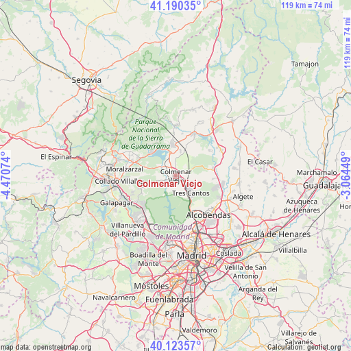
Colmenar Viejo GPS coordinates[2]
40° 39' 32.724" North, 3° 46' 3.432" West
| Map corner | latitude | longitude |
|---|---|---|
| Upper-left | 41.19035°, | -4.47074° |
| Center: | 40.65909°, | -3.76762° |
| Lower-right: | 40.12357°, | -3.06449° |
| Map W x H: | 118.6×118.6 km | = 73.7×73.7mi |
| max Lat: | 43.74134° ⇑58.7% North |
| Colmenar Viejo: | 40.65909° |
| min Lat: | ⇓41.3% South 27.64134° |
| min Long | Colmenar Viejo | max Long |
| -18.00367° | -3.76762° | 4.2899° |
| W 43.7%⇐ | ⇒56.3% E |
Elevation
Elevation of Colmenar Viejo is 889 m = 2917 ft, and this is 291 m = 955 ft above average elevation for this country.
| Max E: |
1682 m = 5518 ft | 21% |
| Colmenar Viejo | 889 m 2917 ft | |
| Avg. | 598 m = 1962 ft | |
Min E: |
0 m = 0 ft | 79% |
See also: Colmenar Viejo elevation on elevation.city.
Geographical zone
Colmenar Viejo is located in North temperate zone (between Tropic of Cancer and the Arctic Circle). Distance of this Northern Tropic circle is 1914.9 km =1189.9 mi to South.| Distance of | km | miles | from Colmenar Viejo |
|---|---|---|---|
| North Pole | 5486.2 | 3409 | to North |
| Arctic Circle | 2880.3 | 1789.7 | to North |
| Tropic Cancer | 1914.9 | 1189.9 | to South |
| Equator | 4520.9 | 2809.2 | to South |


Nearby cities:
15 places around Colmenar Viejo: (largest is in red/bold)
• Alcobendas
16.3 km =10.1 mi,  139°
139°
• Boalo
14.1 km =8.8 mi,  296°
296°
• El Molar
17.8 km =11.1 mi,  62°
62°
• El Pardo
16.1 km =10 mi,  181°
181°
• Guadalix de la Sierra
15.3 km =9.5 mi,  24°
24°
• Hoyo de Manzanares
12.5 km =7.8 mi,  251°
251°
• Las Matas
15.4 km =9.6 mi,  222°
222°
• Manzanares el Real
11 km =6.8 mi,  312°
312°
• Miraflores de la Sierra
17.4 km =10.8 mi,  1°
1°
• Moralzarzal
17.3 km =10.7 mi,  277°
277°
• Pedrezuela
16.9 km =10.5 mi, 56°
• San Agustín del Guadalix
12.9 km =8 mi,  80°
80°
• San Sebastián de los Reyes
16.5 km =10.3 mi,  134°
134°
• Torrelodones
16.3 km =10.1 mi,  235°
235°
• Tres Cantos
8.2 km =5.1 mi, 142°
Sources, notices
• [Note1] Compared only with cities in Spain existing in our database
• [Src1] Map data: © OpenStreetMap contributors (CC-BY-SA)
• [Src2] Other city data from geonames.org with taken over terms of usage.
• [Src3] Geographical zone / Annual Mean Temperature by Robert A. Rohde @ Wikipedia
