Vegacervera geodata
Vegacervera (Castille and León) is a seat of a third-order administrative division; located in Spain in Europe/Madrid (GMT+2) time zone. With population of 335 people, there are 4371 cities with bigger population in this country. Compared to other cities in Spain, 93.5% of cities are located further ↓South; 79.1% of cities are located further →East and 91.5% of cities have lower elevation than Vegacervera. Note1
Administrative division(s):
- Level 1: Castille and León
- Level 2: Provincia de León
- Level 3: Vegacervera


Vegacervera GPS coordinates[2]
42° 53' 17.088" North, 5° 32' 7.764" West
| Map corner | latitude | longitude |
|---|---|---|
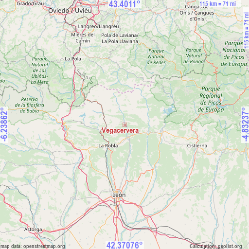
| Upper-left | 43.4011°, | -6.23862° |
| Center: | 42.88808°, | -5.53549° |
| Lower-right: | 42.37076°, | -4.83237° |
| Map W x H: | 114.6×114.6 km | = 71.2×71.2mi |
| max Lat: | 43.74134° ⇑6.5% North |
| Vegacervera: | 42.88808° |
| min Lat: | ⇓93.5% South 27.64134° |
| min Long | Vegacervera | max Long |
| -18.00367° | -5.53549° | 4.2899° |
| W 20.9%⇐ | ⇒79.1% E |
Elevation
Elevation of Vegacervera is 1057 m = 3468 ft, and this is 459 m = 1506 ft above average elevation for this country.
| Max E: |
1682 m = 5518 ft | 8.5% |
| Vegacervera | 1057 m 3468 ft | |
| Avg. | 598 m = 1962 ft | |
Min E: |
0 m = 0 ft | 91.5% |
See also: Spain elevation on elevation.city.
Geographical zone
Vegacervera is located in North temperate zone (between Tropic of Cancer and the Arctic Circle). Distance of this Northern Tropic circle is 2162.8 km =1343.9 mi to South.| Distance of | km | miles | from Vegacervera |
|---|---|---|---|
| North Pole | 5238.4 | 3255 | to North |
| Arctic Circle | 2632.5 | 1635.8 | to North |
| Tropic Cancer | 2162.8 | 1343.9 | to South |
| Equator | 4768.7 | 2963.1 | to South |


Nearby cities:
15 places around Vegacervera: (largest is in red/bold)
• Boñar
17.4 km =10.8 mi,  97°
97°
• Carrocera
19.8 km =12.3 mi,  238°
238°
• Cuadros
21.3 km =13.2 mi,  203°
203°
• Cármenes
8.4 km =5.2 mi,  338°
338°
• Garrafe de Torío
17.3 km =10.7 mi,  176°
176°
• La Pola de Gordón
11.3 km =7 mi,  251°
251°
• La Robla
12.1 km =7.5 mi,  218°
218°
• Matallana de Torío
2.8 km =1.7 mi,  153°
153°
• Puebla de Lillo
25.1 km =15.6 mi,  58°
58°
• Ruayer
18.5 km =11.5 mi,  356°
356°
• Santa Colomba de Curueño
18.3 km =11.4 mi, 146°
• Valdepiélago
11.4 km =7.1 mi, 100°
• Vegaquemada
18.3 km =11.4 mi,  114°
114°
• Villamanín
11.4 km =7.1 mi,  299°
299°
• Villaquilambre
26.9 km =16.7 mi, 183°
Sources, notices
• [Note1] Compared only with cities in Spain existing in our database
• [Src1] Map data: © OpenStreetMap contributors (CC-BY-SA)
• [Src2] Other city data from geonames.org with taken over terms of usage.
• [Src3] Geographical zone / Annual Mean Temperature by Robert A. Rohde @ Wikipedia
