Villamanín geodata
Villamanín (Castille and León) is a seat of a third-order administrative division; located in Spain in Europe/Madrid (GMT+2) time zone. With population of 1,129 people, there are 2795 cities with bigger population in this country. Compared to other cities in Spain, 93.9% of cities are located further ↓South; 81% of cities are located further →East and 94.9% of cities have lower elevation than Villamanín. Note1
Administrative division(s):
- Level 1: Castille and León
- Level 2: Provincia de León
- Level 3: Villamanín


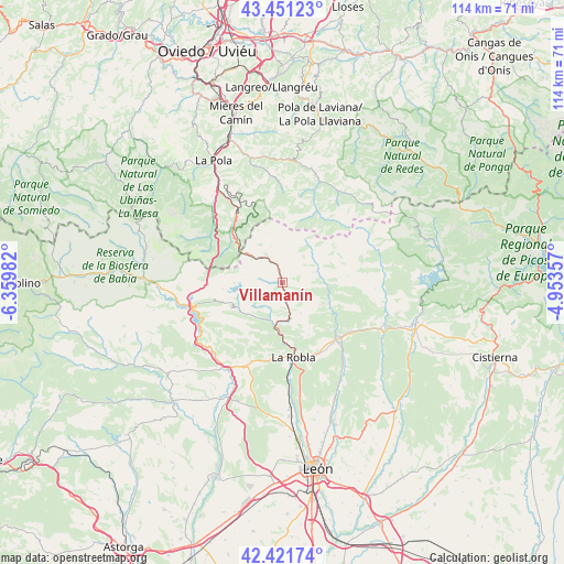
Villamanín GPS coordinates[2]
42° 56' 19.104" North, 5° 39' 24.084" West
| Map corner | latitude | longitude |
|---|---|---|
| Upper-left | 43.45123°, | -6.35982° |
| Center: | 42.93864°, | -5.65669° |
| Lower-right: | 42.42174°, | -4.95357° |
| Map W x H: | 114.5×114.5 km | = 71.1×71.1mi |
| max Lat: | 43.74134° ⇑6.1% North |
| Villamanín: | 42.93864° |
| min Lat: | ⇓93.9% South 27.64134° |
| min Long | Villamanín | max Long |
| -18.00367° | -5.65669° | 4.2899° |
| W 19%⇐ | ⇒81% E |
Elevation
Elevation of Villamanín is 1134 m = 3720 ft, and this is 536 m = 1759 ft above average elevation for this country.
| Max E: |
1682 m = 5518 ft | 5.1% |
| Villamanín | 1134 m 3720 ft | |
| Avg. | 598 m = 1962 ft | |
Min E: |
0 m = 0 ft | 94.9% |
See also: Spain elevation on elevation.city.
Geographical zone
Villamanín is located in North temperate zone (between Tropic of Cancer and the Arctic Circle). Distance of this Northern Tropic circle is 2168.4 km =1347.4 mi to South.| Distance of | km | miles | from Villamanín |
|---|---|---|---|
| North Pole | 5232.7 | 3251.4 | to North |
| Arctic Circle | 2626.8 | 1632.2 | to North |
| Tropic Cancer | 2168.4 | 1347.4 | to South |
| Equator | 4774.3 | 2966.6 | to South |


Nearby cities:
15 places around Villamanín: (largest is in red/bold)
• Boñar
28.3 km =17.6 mi,  106°
106°
• Carrocera
17.4 km =10.8 mi,  204°
204°
• Cuadros
25.3 km =15.7 mi,  176°
176°
• Cármenes
7.1 km =4.4 mi,  71°
71°
• Garrafe de Torío
25.3 km =15.7 mi,  154°
154°
• La Pola de Gordón
9.2 km =5.7 mi,  185°
185°
• La Robla
15.2 km =9.4 mi,  171°
171°
• Matallana de Torío
13.8 km =8.6 mi,  126°
126°
• Ruayer
15.5 km =9.6 mi,  34°
34°
• San Emiliano
28.2 km =17.5 mi,  277°
277°
• Santa María de Ordás
27.2 km =16.9 mi,  209°
209°
• Sena de Luna
24.1 km =15 mi,  267°
267°
• Soto y Amío
26.2 km =16.3 mi,  225°
225°
• Valdepiélago
22.5 km =14 mi, 110°
• Vegacervera
11.4 km =7.1 mi,  119°
119°
Sources, notices
• [Note1] Compared only with cities in Spain existing in our database
• [Src1] Map data: © OpenStreetMap contributors (CC-BY-SA)
• [Src2] Other city data from geonames.org with taken over terms of usage.
• [Src3] Geographical zone / Annual Mean Temperature by Robert A. Rohde @ Wikipedia
