Cármenes geodata
Cármenes (Castille and León) is a seat of a third-order administrative division; located in Spain in Europe/Madrid (GMT+2) time zone. With population of 425 people, there are 4064 cities with bigger population in this country. Compared to other cities in Spain, 94.1% of cities are located further ↓South; 79.7% of cities are located further →East and 95.8% of cities have lower elevation than Cármenes. Note1


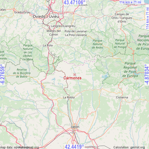
Cármenes GPS coordinates[2]
42° 57' 31.068" North, 5° 34' 24.456" West
| Map corner | latitude | longitude |
|---|---|---|
| Upper-left | 43.47106°, | -6.27659° |
| Center: | 42.95863°, | -5.57346° |
| Lower-right: | 42.4419°, | -4.87034° |
| Map W x H: | 114.4×114.4 km | = 71.1×71.1mi |
| max Lat: | 43.74134° ⇑5.9% North |
| Cármenes: | 42.95863° |
| min Lat: | ⇓94.1% South 27.64134° |
| min Long | Cármenes | max Long |
| -18.00367° | -5.57346° | 4.2899° |
| W 20.3%⇐ | ⇒79.7% E |
Elevation
Elevation of Cármenes is 1162 m = 3812 ft, and this is 564 m = 1850 ft above average elevation for this country.
| Max E: |
1682 m = 5518 ft | 4.2% |
| Cármenes | 1162 m 3812 ft | |
| Avg. | 598 m = 1962 ft | |
Min E: |
0 m = 0 ft | 95.8% |
See also: Spain elevation on elevation.city.
Geographical zone
Cármenes is located in North temperate zone (between Tropic of Cancer and the Arctic Circle). Distance of this Northern Tropic circle is 2170.6 km =1348.7 mi to South.| Distance of | km | miles | from Cármenes |
|---|---|---|---|
| North Pole | 5230.5 | 3250.1 | to North |
| Arctic Circle | 2624.6 | 1630.9 | to North |
| Tropic Cancer | 2170.6 | 1348.7 | to South |
| Equator | 4776.6 | 2968 | to South |


Nearby cities:
15 places around Cármenes: (largest is in red/bold)
• Boñar
22.7 km =14.1 mi,  116°
116°
• Carrocera
22.8 km =14.2 mi,  217°
217°
• Cuadros
28 km =17.4 mi,  190°
190°
• Garrafe de Torío
25.4 km =15.8 mi,  170°
170°
• La Pola de Gordón
13.7 km =8.5 mi,  214°
214°
• La Robla
17.9 km =11.1 mi, 194°
• Matallana de Torío
11.2 km =7 mi,  157°
157°
• Puebla de Lillo
25 km =15.5 mi,  77°
77°
• Reyero
30.5 km =19 mi,  92°
92°
• Ruayer
10.7 km =6.6 mi,  10°
10°
• Santa Colomba de Curueño
26.6 km =16.5 mi,  150°
150°
• Valdepiélago
17.4 km =10.8 mi, 124°
• Vegacervera
8.4 km =5.2 mi, 158°
• Vegaquemada
25.1 km =15.6 mi,  128°
128°
• Villamanín
7.1 km =4.4 mi,  251°
251°
Sources, notices
• [Note1] Compared only with cities in Spain existing in our database
• [Src1] Map data: © OpenStreetMap contributors (CC-BY-SA)
• [Src2] Other city data from geonames.org with taken over terms of usage.
• [Src3] Geographical zone / Annual Mean Temperature by Robert A. Rohde @ Wikipedia
