Albalate de Zorita geodata
Albalate de Zorita (Castille-La Mancha) is a seat of a third-order administrative division; located in Spain in Europe/Madrid (GMT+2) time zone. With population of 780 people, there are 3252 cities with bigger population in this country. Compared to other cities in Spain, 65.6% of cities are located further ↑North; 56.9% of cities are located further ←West and 64% of cities have lower elevation than Albalate de Zorita. Note1
Administrative division(s):
- Level 1: Castille-La Mancha
- Level 2: Provincia de Guadalajara
- Level 3: Albalate de Zorita


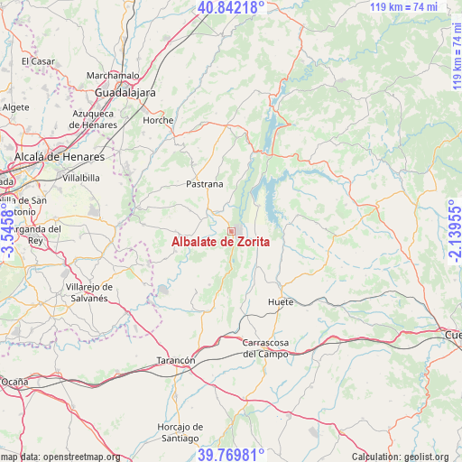
Albalate de Zorita GPS coordinates[2]
40° 18' 29.232" North, 2° 50' 33.612" West
| Map corner | latitude | longitude |
|---|---|---|
| Upper-left | 40.84218°, | -3.5458° |
| Center: | 40.30812°, | -2.84267° |
| Lower-right: | 39.76981°, | -2.13955° |
| Map W x H: | 119.2×119.2 km | = 74.1×74.1mi |
| max Lat: | 43.74134° ⇑65.6% North |
| Albalate de Zorita: | 40.30812° |
| min Lat: | ⇓34.4% South 27.64134° |
| min Long | Albalate de Zor | max Long |
| -18.00367° | -2.84267° | 4.2899° |
| W 56.9%⇐ | ⇒43.1% E |
Elevation
Elevation of Albalate de Zorita is 771 m = 2530 ft, and this is 173 m = 568 ft above average elevation for this country.
| Max E: |
1682 m = 5518 ft | 36% |
| Albalate de Zorita | 771 m 2530 ft | |
| Avg. | 598 m = 1962 ft | |
Min E: |
0 m = 0 ft | 64% |
See also: Spain elevation on elevation.city.
Geographical zone
Albalate de Zorita is located in North temperate zone (between Tropic of Cancer and the Arctic Circle). Distance of this Northern Tropic circle is 1875.9 km =1165.6 mi to South.| Distance of | km | miles | from Albalate de Zorita |
|---|---|---|---|
| North Pole | 5525.2 | 3433.2 | to North |
| Arctic Circle | 2919.3 | 1814 | to North |
| Tropic Cancer | 1875.9 | 1165.6 | to South |
| Equator | 4481.8 | 2784.9 | to South |


Nearby cities:
15 places around Albalate de Zorita: (largest is in red/bold)
• Albares
14.1 km =8.8 mi,  269°
269°
• Almoguera
11.9 km =7.4 mi,  264°
264°
• Almonacid de Zorita
2.4 km =1.5 mi,  344°
344°
• Buendía
9.8 km =6.1 mi,  48°
48°
• Escopete
18 km =11.2 mi,  310°
310°
• Illana
14.9 km =9.3 mi,  202°
202°
• Mazuecos
15 km =9.3 mi,  249°
249°
• Pastrana
14.1 km =8.8 mi,  331°
331°
• Pozo de Almoguera
16 km =9.9 mi,  282°
282°
• Saceda-Trasierra
17 km =10.6 mi,  183°
183°
• Sayatón
7.6 km =4.7 mi,  353°
353°
• Valdeconcha
16.7 km =10.4 mi, 350°
• Villalba del Rey
17.8 km =11.1 mi,  76°
76°
• Yebra
11.8 km =7.3 mi,  297°
297°
• Zorita de los Canes
4.6 km =2.9 mi, 303°
Sources, notices
• [Note1] Compared only with cities in Spain existing in our database
• [Src1] Map data: © OpenStreetMap contributors (CC-BY-SA)
• [Src2] Other city data from geonames.org with taken over terms of usage.
• [Src3] Geographical zone / Annual Mean Temperature by Robert A. Rohde @ Wikipedia
