Espinosa de Cerrato geodata
Espinosa de Cerrato (Castille and León) is a seat of a third-order administrative division; located in Spain in Europe/Madrid (GMT+2) time zone. With population of 208 people, there are 4993 cities with bigger population in this country. Compared to other cities in Spain, 72.8% of cities are located further ↓South; 59% of cities are located further →East and 78.8% of cities have lower elevation than Espinosa de Cerrato. Note1
Administrative division(s):
- Level 1: Castille and León
- Level 2: Provincia de Palencia
- Level 3: Espinosa de Cerrato


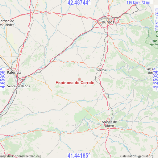
Espinosa de Cerrato GPS coordinates[2]
41° 58' 0.444" North, 3° 57' 12.456" West
| Map corner | latitude | longitude |
|---|---|---|
| Upper-left | 42.48744°, | -4.65659° |
| Center: | 41.96679°, | -3.95346° |
| Lower-right: | 41.44185°, | -3.25034° |
| Map W x H: | 116.3×116.3 km | = 72.3×72.3mi |
| max Lat: | 43.74134° ⇑27.2% North |
| Espinosa de Cerrato: | 41.96679° |
| min Lat: | ⇓72.8% South 27.64134° |
| min Long | Espinosa de Cer | max Long |
| -18.00367° | -3.95346° | 4.2899° |
| W 41%⇐ | ⇒59% E |
Elevation
Elevation of Espinosa de Cerrato is 886 m = 2907 ft, and this is 288 m = 945 ft above average elevation for this country.
| Max E: |
1682 m = 5518 ft | 21.2% |
| Espinosa de Cerrato | 886 m 2907 ft | |
| Avg. | 598 m = 1962 ft | |
Min E: |
0 m = 0 ft | 78.8% |
See also: Spain elevation on elevation.city.
Geographical zone
Espinosa de Cerrato is located in North temperate zone (between Tropic of Cancer and the Arctic Circle). Distance of this Northern Tropic circle is 2060.4 km =1280.3 mi to South.| Distance of | km | miles | from Espinosa de Cerrato |
|---|---|---|---|
| North Pole | 5340.8 | 3318.6 | to North |
| Arctic Circle | 2734.9 | 1699.4 | to North |
| Tropic Cancer | 2060.4 | 1280.3 | to South |
| Equator | 4666.3 | 2899.5 | to South |


Nearby cities:
15 places around Espinosa de Cerrato: (largest is in red/bold)
• Antigüedad
14 km =8.7 mi,  260°
260°
• Avellanosa de Muñó
10.7 km =6.6 mi,  80°
80°
• Cilleruelo de Abajo
15.9 km =9.9 mi,  125°
125°
• Cobos de Cerrato
7.9 km =4.9 mi,  329°
329°
• Iglesiarrubia
8.8 km =5.5 mi, 84°
• Mahamud
17 km =10.6 mi,  3°
3°
• Peral de Arlanza
15.9 km =9.9 mi,  319°
319°
• Quintanilla de la Mata
15.6 km =9.7 mi, 81°
• Royuela de Río Franco
3.9 km =2.4 mi,  357°
357°
• Santa Cecilia
15.6 km =9.7 mi,  52°
52°
• Tabanera de Cerrato
15.5 km =9.6 mi,  294°
294°
• Tordómar
11.5 km =7.1 mi,  39°
39°
• Torresandino
15.7 km =9.8 mi,  166°
166°
• Villafruela
6.5 km =4 mi,  149°
149°
• Villahoz
12.6 km =7.8 mi,  15°
15°
Sources, notices
• [Note1] Compared only with cities in Spain existing in our database
• [Src1] Map data: © OpenStreetMap contributors (CC-BY-SA)
• [Src2] Other city data from geonames.org with taken over terms of usage.
• [Src3] Geographical zone / Annual Mean Temperature by Robert A. Rohde @ Wikipedia
