Argavieso geodata
Argavieso (Aragon) is a seat of a third-order administrative division; located in Spain in Europe/Madrid (GMT+2) time zone. With population of 125 people, there are 5639 cities with bigger population in this country. Compared to other cities in Spain, 75.2% of cities are located further ↓South; 84.8% of cities are located further ←West and 63.2% of cities have higher elevation than Argavieso. Note1


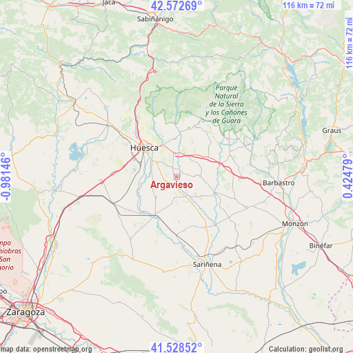
Argavieso GPS coordinates[2]
42° 3' 9.9" North, 0° 16' 42.024" West
| Map corner | latitude | longitude |
|---|---|---|
| Upper-left | 42.57269°, | -0.98146° |
| Center: | 42.05275°, | -0.27834° |
| Lower-right: | 41.52852°, | 0.42479° |
| Map W x H: | 116.1×116.1 km | = 72.1×72.1mi |
| max Lat: | 43.74134° ⇑24.8% North |
| Argavieso: | 42.05275° |
| min Lat: | ⇓75.2% South 27.64134° |
| min Long | Argavieso | max Long |
| -18.00367° | -0.27834° | 4.2899° |
| W 84.8%⇐ | ⇒15.2% E |
Elevation
Elevation of Argavieso is 484 m = 1588 ft, and this is 114 m = 374 ft below average elevation for this country.
| Max E: |
1682 m = 5518 ft | 63.2% |
| Avg. | 598 m = 1962 ft | |
| Argavieso | 484 m = 1588 ft | |
Min E: |
0 m = 0 ft | 36.8% |
See also: Spain elevation on elevation.city.
Geographical zone
Argavieso is located in North temperate zone (between Tropic of Cancer and the Arctic Circle). Distance of this Northern Tropic circle is 2069.9 km =1286.2 mi to South.| Distance of | km | miles | from Argavieso |
|---|---|---|---|
| North Pole | 5331.2 | 3312.7 | to North |
| Arctic Circle | 2725.3 | 1693.4 | to North |
| Tropic Cancer | 2069.9 | 1286.2 | to South |
| Equator | 4675.8 | 2905.4 | to South |


Nearby cities:
15 places around Argavieso: (largest is in red/bold)
• Albero Alto
4.9 km =3 mi,  266°
266°
• Albero Bajo
9 km =5.6 mi,  249°
249°
• Alcalá del Obispo
2.9 km =1.8 mi,  338°
338°
• Angüés
12.2 km =7.6 mi,  57°
57°
• Antillón
9.7 km =6 mi,  100°
100°
• Ibieca
13.3 km =8.3 mi,  25°
25°
• Loporzano
12.6 km =7.8 mi, 342°
• Novales
2.4 km =1.5 mi,  197°
197°
• Piracés
6.3 km =3.9 mi,  211°
211°
• Quicena
12.6 km =7.8 mi,  327°
327°
• Salillas
7.9 km =4.9 mi,  144°
144°
• Sesa
7 km =4.3 mi,  156°
156°
• Siétamo
7.9 km =4.9 mi,  358°
358°
• Tierz
11 km =6.8 mi,  324°
324°
• Tramaced
9 km =5.6 mi,  190°
190°
Sources, notices
• [Note1] Compared only with cities in Spain existing in our database
• [Src1] Map data: © OpenStreetMap contributors (CC-BY-SA)
• [Src2] Other city data from geonames.org with taken over terms of usage.
• [Src3] Geographical zone / Annual Mean Temperature by Robert A. Rohde @ Wikipedia
